
Event Headlines
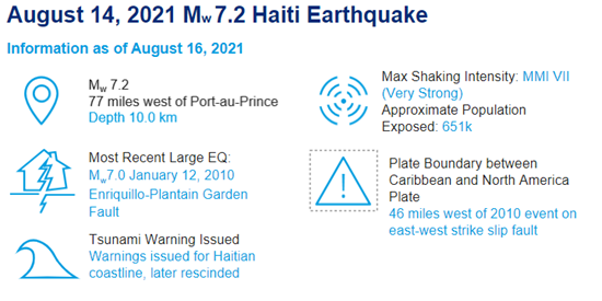
- A large Mw 7.2 earthquake erupted Saturday August 14, 2021 on the Enriquillo-Plantain Garden Fault Zone in southwest Haiti, 78 miles west of the capital of Port-au-Prince, Haiti.
- Significant damage is being reported across southwest Haiti, with recovery efforts hindered by heavy rainfall associated with Tropical Storm Grace and political instability.
- Initial damage reports in the capital of Port-au-Prince are not as devastating as was seen in 2010 when 200,000-300,000 fatalities occurred. The 2010 event was only 15 miles west of Port-au-Prince. The 2021 earthquake was two times more powerful than the 2010 Mw 7.0 Haiti earthquake. Due to the convergence of the North America and Caribbean plates, Haiti and other northern Caribbean countries are susceptible to large earthquakes.

Shake Intensity Map of M7.2 Haiti Earthquake. Source: USGS.
Regional Impacts
As of Monday August 16th, the Haiti death toll stands at 1,297 people with at least 5,700 additional injuries. The US Geological Survey is estimating high levels of casualties and widespread disaster as a result of the earthquake, with a 35% likelihood of fatalities between 10,000 and 100,000 people and a more dire 37% likelihood of fatalities in excess of 100,000 people. Economic losses will be significant as well, with a 36% likelihood of economic losses between $1.0bn to $10.0bn, with a 25% likelihood losses are in excess of $10bn. Outside of the capital of Port-au-Prince, insurance penetration for earthquakes is minimal, and thus the majority of the loss is likely to be uninsured.

Estimated Fatalities and Economic Losses. Source: USGS Pager Report.
Notable Impacts by Sector


Comparison to Historical Events
The island of Hispaniola is an area of frequent and strong seismic activity. Four Mw 7.0 or higher earthquakes and an additional twelve events between Mw 6.0 and Mw 6.9 have transpired since 1900. Further back in history, the capital of Port-au-Prince was destroyed in earthquakes in both the 18th and 19th centuries. The most recent devastating earthquake in January 2010 has been widely studied due to the significant loss of life with best estimates of 200,000 to 300,000 people. The boundary between the North America and Caribbean plate stretches across Hispaniola, southern Cuba, Jamaica and around Puerto Rico, resulting in the elevated frequency of severe earthquakes in this portion of the Caribbean Sea.

Historical Caribbean Earthquakes and Plate Tectonics. Source: USGS.
Additional Links:
- USGS 2020 M7.2 Haiti Earthquake Analysis
- USGS 2010 M7.0 Haiti Earthquake Report
- Overview of the 2010 Haitian Earthquake