
Key Headlines
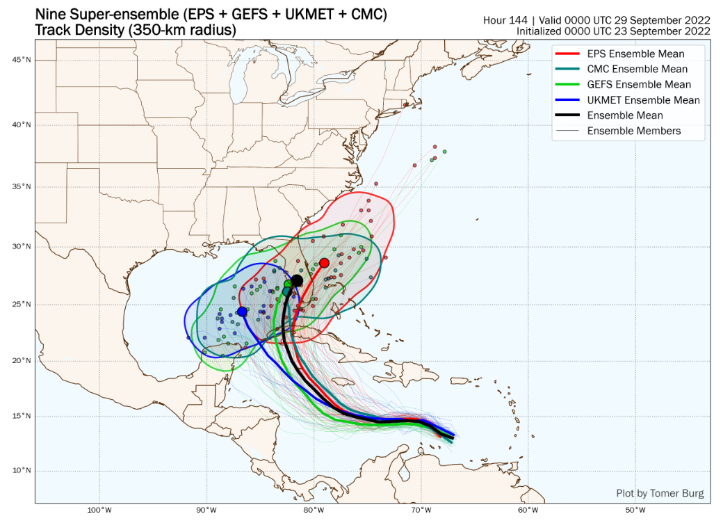
- Increasing Potential for a Major US Hurricane Landfall Next Week: The National Hurricane Center initiated advisories on Tropical Depression #9 in the eastern Caribbean overnight. The official five day forecast calls for TD #9 to achieve hurricane status by early Monday, with the 5 day cone of uncertainty encompassing the southern half of Florida as potential category-3 landfall in the middle of next week. Over 50% of total model guidance overnight indicates a Florida landfall mid to late next week after rapidly intensifying in the southeastern Gulf of Mexico.
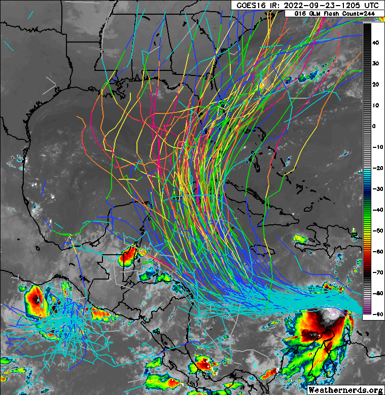
- But First, TD #9 Needs to Become Better Organized: The tropical depression is currently disorganized, as a result of upper level north-to-south wind shear from the outflow of Hurricane Fiona. The combination of continued wind shear through the weekend along with dry air ahead of the storm will result in minimal strengthening in the next 48 hours. There is a low probability TD #9 could fail to organize if conditions are hostile enough on Saturday and Sunday.
- If Organized by Sunday, Near Ideal Conditions for Intensification: Assuming TD #9 is intact west of Jamaica, conditions look nearly perfect for intensification, potentially rapidly. Well above average sea surface temperatures, low levels of wind shear and upper level winds are all factors favorable for strengthening. While land interaction across Cuba will cause some disruption, the stronger the storm before a Cuba landfall, the more likely it will be intact in the southeastern Gulf of Mexico.
- Tropical Depression #10 Forms in East Atlantic: NHC initiated advisories on TD #10 in the far eastern Atlantic midday Friday. The forecast calls for this depression to track out to sea. It is possible this becomes a named storm before the Caribbean tropical depression. The next two names for the Atlantic basin are Hermine and Ian.

- Analogs to the current TD #9 Forecast: Taking a 120 mile radius around Naples, FL and examining hurricanes of category 2-4 intensity in this circle making landfall moving west to east, 19 landfalls have occurred since 1850 with an additional two bypass events. However, only three events have transpired since the mid 1960s: Cat-3 Irma (Sept. 2017), Cat-3 Wilma (Oct. 2005) and Cat-4 Charley (August 2004). 13 of the 21 hurricanes transpired in October, and 11 of 21 were category-3 or category-4 strength. All but two of these events underwent significant intensification in the northwestern Caribbean and southeast Gulf of Mexico prior to landfall. The two exceptions tracking north of the Caribbean before turning north towards southwest Florida were Irma (2017) and Donna (1960).


Additional links of interest:
U.S. National Hurricane Center
U.S. National Weather Service
NWS Key West, FL
NWS Tampa Bay, FL
NWS Miami, FL
Historical Hurricane Track Map
The next update on Tropical Depression #9 will be likely issued on Sunday afternoon as confidence in the forecast will be increasing through the weekend.