
Key Headlines
- Increasing Confidence in Lee Weakening Materially Before Landfall After Passing Bermuda: Passing west of Bermuda, tropical storm warnings are in effect for the island. Once Lee progresses further north past the Gulf Stream, coinciding with the upwelled cooler waters left from Idalia and Franklin, model guidance suggests Lee will weaken into the early weekend. Lee will degrade to a category-1 strength storm by late Friday and to tropical storm / post tropical storm status by Sunday.
- Landfall Region of Highest Confidence: The central to downeast Maine coastline east into the western third of Nova Scotia is the most probable landfall zone. However, Lee's windfield will continue to expand until landfall, therefore tropical storm force winds cannot be ruled out several hundred miles away from the center, including the New England coastline from Massachusetts north to New Brunswick and eventually Prince Edward Island.
- Storm Surge a Threat for Low Lying Areas: The Northeast US and Atlantic Canada coastline is known for steeper topography at the coast, however low lying regions will potentially see 3-5 feet of storm surge in the Gulf of Maine and higher levels of 6-9 feet in the Bay of Fundy.
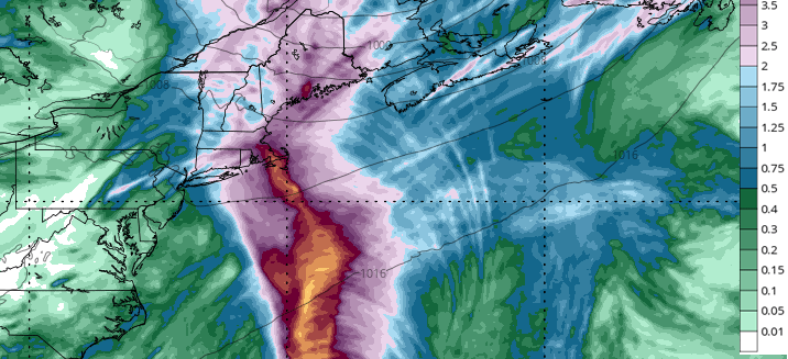
- Rainfall in New England on Top of a Wet Summer: Rainfall of 4-6" with isolated heavier amounts are anticipated along the coastal areas of New England and into New Brunswick and Nova Scotia. With rainfall totals running 150% to 200%+ above normal in some areas of the Northeast the last 90 days, saturated soils could escalate runoff potential as well as elevated treefall risk.
- Lee is not a Repeat of Hurricane Fiona (2022) Impacts to Nova Scotia and Prince Edward Island: Fiona made landfall as a potent extratropical storm with a central pressure in the low 930 mb range with maximum sustained winds of 110 mph; Lee will pale in comparison to Fiona's damage a year earlier in Canada. Settling at an insured loss of $800M CAN dollars (Insurance Bureau of Canada), Fiona ranked the seventh worst natural disaster for insurance payouts in Canada history.
- Historic Analogs: Several storms in recorded history (since 1851) have affected the Bay of Fundy, following a northward path through the Atlantic like that of Hurricane Lee. With respect to Lee, these storms fall into one of three categories:
- Accurate track, too intense: Hurricanes Carol (1953) and Kyle (2008), as well as another from 1940, passed approximately 150 miles west of Halifax into the Bay of Fundy as category one storms. Lee is currently projected to make landfall at tropical storm status or weaker.
- Accurate intensity, too far east: Several unnamed storms from 1918 and 1936, as well as Hurricane Karen (2001), impacted the region at tropical storm intensity, but made landfall closer inland to Halifax.
- Accurate track, accurate intensity: Hurricane Daisy (1962) and an unnamed storm in 1937 are the closest historical analogs for Hurricane Lee.
- Tropical Storm Heidi (1971) made landfall south of Ellsworth, ME and provides insight to a potential westward shift in Lee’s track, as suggested by some hurricane ensembles.


Additional links of interest:
NOAA Storm Surge Data
U.S. National Hurricane Center
Hurricane Lee Satellite Loop
Bermuda Weather Service
Environment Canada Hurricane Site