
Key Headlines
- Above average severe convective storm activity has defined 2024 to date. A persistent heat dome over the Gulf of Mexico and cooler upper-level temperatures over the Central United States have created a strong temperature gradient to fuel this activity.
- Storm reports for all major SCS (Severe Convective Storm) sub-perils (Hail, Tornado, Wind) are running above the 2005-2015 annual average. Hail reports have been closer to the annual mean, while wind reports are ~45% above the mean (as of June 4), fueled in part by a powerful derecho that impacted the Gulf Coast on May 16.
- Tornado local storm reports are currently second highest on record since 2010, trailing only the hyperactive 2011 season. More than 1,100 tornados have been reported to date, with over 120 of them occurring during a prolific outbreak in late April (Figure 1).
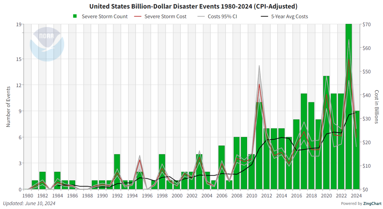
- As of May 31, nine SCS events surpassed the USD $1 billion damage threshold in 2024 according to the NCEI-NOAA United States Billion Dollar Disaster Events dataset, with total costs exceeding USD $22 billion.
- Large scale weather pattern forecasts indicate that the severe threat may migrate into the Northern Plains in the second half of June. Additionally, the development of a La Niña may help induce additional severe thunderstorm activity in the summer. Interests in property (re)insurance should be prepared for further SCS impacts as we progress further into the summer.
SCS Activity to Date
In a year defined by above average wind and tornado activity, January began quickly. On January 8-10 a strong mid-latitude cyclone tracked north from the Gulf Coast and into the Ohio River Valley, triggering widespread severe weather in its warm sector. A tornado outbreak occurred along the Gulf Coast with over 38 reported tornados, including a damaging EF3 tornado that impacted Panama City Beach, Florida. The severe outbreak associated with this cyclone also produced damaging winds across the Southeast; the 350+ individual wind damage reports on January 9 remain the second most active day of 2024 with regards to wind damage. All told, the January 8-10 outbreak generated an estimated USD $2.7 billion in damages according to NOAA. This “off-season” outbreak aligns with recent observed trends that show an increase in severe weather activity in the cold seasons, which ultimately play a role in the overall increase in severe convective storm damages across the United States.
All severe thunderstorm reports, including hail, wind, and tornado, for May 2024, courtesy of the US National Weather Service and the Storm Prediction Center.

Additional mid-latitude cyclones triggered severe weather activity across the Deep South over the following months to keep sub-peril counts near or above annual averages. By late spring, atmospheric conditions conducive to persistent severe thunderstorm activity began to emerge. A strong heat dome developed over drought-stricken Central America and the adjoining Gulf of Mexico, while simultaneously a persistent cool upper-level troughing pattern emerged over the Rocky Mountains and central US. These nearby regimes created a strong temperature gradient across the Great Plains and Gulf Coast, generating favorable conditions for severe thunderstorm outbreaks.
Favorable conditions for severe thunderstorms persisted throughout May, with several additional outbreaks occurring. On May 6, the SPC issued a rare “High” risk for severe weather, a forecast that verified itself as an EF4 tornado devastated Barnsdall, Oklahoma, later that evening. On May 15-18, the severe weather threat focused on the Gulf Coast, headlined by a powerful derecho which swept through Texas and Louisiana on May 16. The derecho peaked near Houston, Texas, producing wind gusts in excess of 100 mph, which caused extensive straight-line wind damage to power infrastructure and property in the metropolitan area. Over 600 wind damage reports were filed on the day of the derecho, playing a major role in 2024 wind counts being ~45% above the 2005-2015 national average as of June 4.
Billion dollar insured disasters have been on the rise for severe convective storms in recent years. As of May 31, there have been 9 SCS events of USD 1 billion or greater across the United States, with costs exceeding USD 22 billion (Figure 4). Uniquely, there have been few prolific hailstorms in populous locales to drive insured losses this year. Typically, hail is the largest driver of SCS losses, yet 2024 has seen tornado and straight-line winds dominate storm reports. Even with the relative dearth of damaging hail events, (re)insurers should remain wary of future hail losses moving into the summer.
Rest of the Season
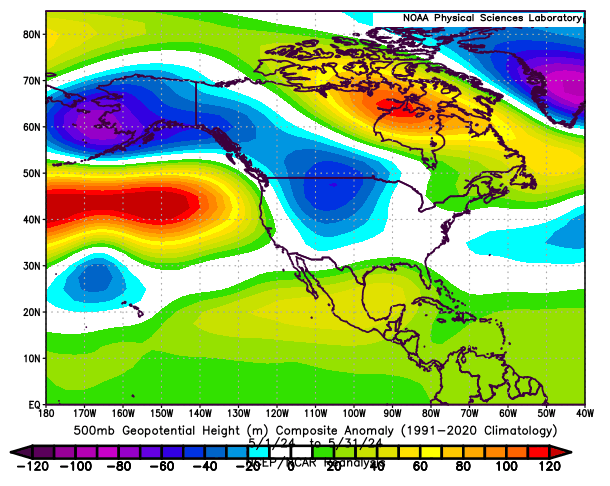
During the transition from spring to summer, climatology indicates that severe weather threats will generally shift northward. At the start of summer, a pattern shift is underway that aligns with this historical precedent. Strong high pressure is expected to take control of the western US. Across the upper Great Plains and Midwest, northwesterly flow downstream of this high pressure will transport cool air into the region, setting up a trough and a strong temperature gradient that has the potential to ignite more severe weather outbreaks, specifically in Nebraska, Iowa, and the rest of the Northern Plains.
Simultaneously, severe convective storm activity will likely decrease across the South. While the overarching pattern is changing, a continuation of the active 2024 thunderstorm season appears likely through June. The use of large-scale patterns in the atmosphere, such as El Niño Southern Oscillation (ENSO), to predict severe thunderstorm activity is difficult due to the stochastic nature of the events, though some large-scale pattern assumptions can be made using these methods. In recent months, the Pacific Ocean has been undergoing a transition from El Niño to ENSO-neutral, with forecasts for a La Niña state by late summer.