Key Headlines:
- Major Hurricane Beryl made landfall on Carriacou Island in the Grenadines on Monday, July 1 as a Category 4 hurricane with sustained winds of 150mph. Extensive damage to property and infrastructure has been observed across Grenada and St. Vincent and the Grenadines.
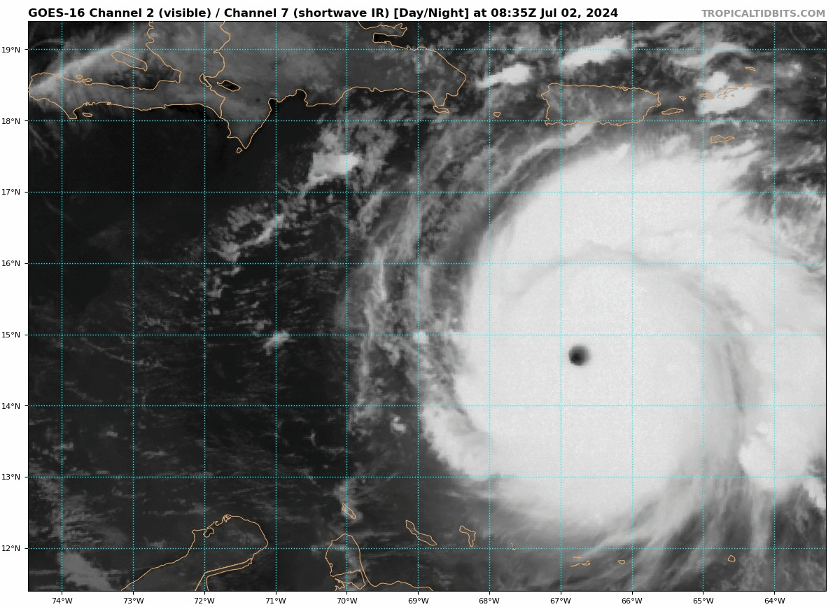
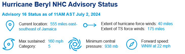
- Beryl emerged into the Eastern Caribbean and continued to intensify overnight on July 2, achieving Category 5 strength with sustained winds of 165mph. This makes Beryl the earliest Category 5 storm observed in the Atlantic Ocean and the strongest July Atlantic hurricane on record. Beryl’s intensification of 55 knots in 24 hours is the earliest on record and can be attributed in part to extremely high ocean heat content in the Atlantic.
- The NHC best forecast calls for the center of Beryl to pass near or over Jamaica on Wednesday and just south of the Cayman Islands on Thursday. If Beryl makes landfall on Jamaica, it would be the first major hurricane landfall since Hurricane Gilbert (1988). Interests in these countries should monitor the forecast closely over the coming days.
- A large amount of uncertainty exists in the forecast for Beryl’s track and intensity beyond the next 3 days. It is uncertain how much wind shear, possible interaction with Jamaican terrain, and steering patterns, among other things, will impact the storm’s intensity and track as it approaches the Gulf of Mexico over the weekend.

Impacts to the Windward Islands:
Significant damage has been reported throughout the Grenadines, Grenada (particularly Carriacou and Petite Martinique), Barbados, and Tobago. In a press conference, Grenada prime minister Dickon Mitchell quoted “widespread reports of destruction and devastation in Carriacou and Petite Martinique,” going on to say, “in half an hour, Carriacou was flattened.” Extensive storm surge and significant building damage, including roof loss, has been reported across impacted islands, and no electricity is present across many. Officials estimate nearly 90 percent of homes damaged or destroyed on Union Island of Saint Vincent and the Grenadines.
Forecast:
Hurricane Beryl has tapped into the anomalously water waters in the eastern Caribbean and has intensified to the season’s first category-5 storm and the earliest category-5 storm on record. It is expected to bring hurricane force winds and damaging storm surge to Jamaica on Wednesday and the Cayman Islands as it bypasses on Thursday. There is still a significant amount of uncertainty in the forecast for both the track and intensity of Hurricane Beryl after it passes further into the Caribbean. Forecast models generally agree that Beryl will weaken before making landfall in the Yucatan as a hurricane by Friday. However, the forecasted intensity is uncertain due to interaction with terrain in Jamaica, increasing vertical wind shear, dry air intrusion, while still benefitting from the availability of warm water as a source of fuel. The National Hurricane Center (NHC) predicts that Beryl will emerge into the Gulf of Mexico as a tropical storm, and there is a possibility of impacts to Texas as the high pressure system steering the storm westward begins to lift, allowing for a northward storm motion.


Peril Advisory will continue to monitor Hurricane Beryl. The next report will be issued after an initial assessment of any damages across Jamaica and forecast clarity for the Yucatán Peninsula and further progression. We currently anticipate the next report to be distributed late week or over the weekend.
Additional links of interest:
- National Hurricane Center
- National Hurricane Center Beryl Advisory Page
- Meteorological Service Jamaica
- National Weather Service
Statements from official forecast and emergency management agencies supersede this update, and should be closely followed concerning matters of personal safety.