This report commemorates the 25th anniversary of Taiwan’s 1999 Chi-Chi Earthquake. The resulting loss of lives, property and economic damages motivated the development of a society that is more resilient against future earthquakes. The subsequent actions included upgrading building codes, improving adherences, retrofitting existing buildings and creating a residential earthquake insurance fund. These efforts have contributed to saving lives, reducing injuries and lowering property damages in post-Chi-Chi events.
CHI-CHI EARTHQUAKE: RESILIENCE AFTER 25 YEARS
Introduction
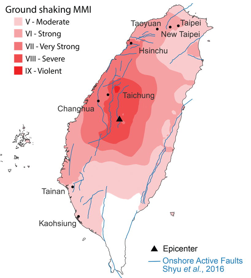
In the early hours (1:47 a.m.) of September 21, 1999, Taiwan was struck by the devastating Mw 7.7 [1] Chi-Chi Earthquake, also known locally as the 921 Earthquake. This event was felt across the island at various shaking intensities as shown in Figure 1.
Figure 1: The Modified Mercalli Intensities (MMI) distribution of 1999 Chi-Chi Earthquake by USGS.
Source: USGS
The epicenter was in the central county of Nantou, but the damage extended to the northern neighbor, Taichung, and beyond. Overall, Chi-Chi caused over 2,400 fatalities, injured 10,000 and left 100,000 people homeless. It was the second-deadliest earthquake in the island’s history after the 1935 Mw 7.1 Hsinchu-Taichung Earthquake, which had its epicenter in Taichung and claimed over 3,000 lives.
Chi-Chi destroyed 51,712 households completely and caused another 53,768 to be half-destroyed. Residential losses totaled TWD [2] 128.4 billion, and the estimated economic loss was TWD 300 billion. The initial shock lasted 102 seconds, and was followed by many aftershocks and landslides, defoliating green mountains, and damaging bridges, levees, dams and highways. Provincial Highway 8, an important route to the east coast, took many years to be completely repaired. A total of 870 schools, from primary to tertiary educational institutions, suffered severe damage, with 293 totally destroyed.
In addition to direct property losses, the manufacturing sector experienced indirect business losses because of power outages. Moreover, the impact on the semiconductor manufacturing and silicon processing plants at the Hsinchu Science Park created a worldwide shortage of computer chips resulting in higher global prices for a brief period.
As a result of the earthquake, government revenues decreased through exemptions to property, income and sales taxes in the affected areas. Banks lost income from mortgage and other loan defaults, deferred mortgage payments, extensions of business loans and decreased savings. Banks also provided low interest rates for reconstruction projects. The stock market paused trading for 2 days.
Despite the regular occurrence of earthquakes in Taiwan, it had been more than half a century since an earthquake with similar impact to Chi-Chi had occurred. Therefore, this major event revived the concern to make Taiwan’s society more resilient against future earthquakes.
Earthquake Hazard
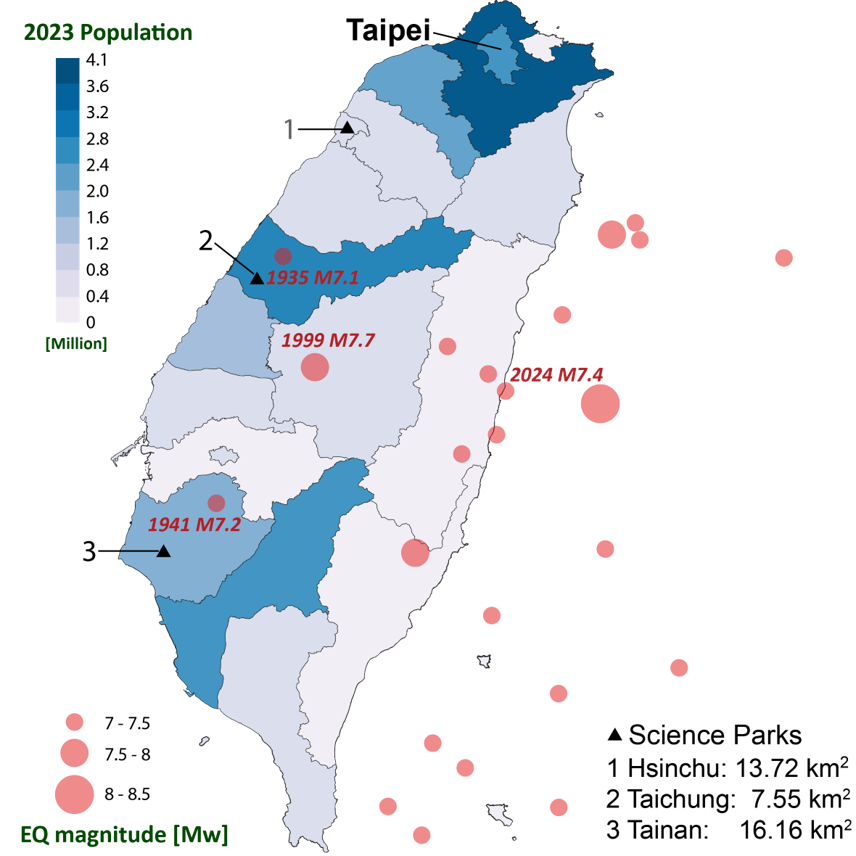
Taiwan is located at a highly active tectonic boundary, between the Eurasian and Philippine Sea plates. High rates of both horizontal and vertical plate deformation generate frequent seismic activity in this region, both on land and offshore. Figure 2 superimposes earthquakes with Mw 7 or above from 1900 on the county population.
Figure 2: County population and historical earthquake events (Mw>7).
Sources: ISC-GEM 9 (International Seismological Centre-Global Earthquake Model), Department of Household Registration
The recent historical record indicates that earthquakes occur more frequently on the eastern side of the island, with many offshore epicenters. Since 1900, all but 3 earthquakes with magnitude > Mw 7.0 were offshore or with epicenters in the 3 eastern counties. Table 1 shows the 3 onshore events with epicenter in the western counties.
Table 1: Mw 7+ earthquakes in western counties since 1900.
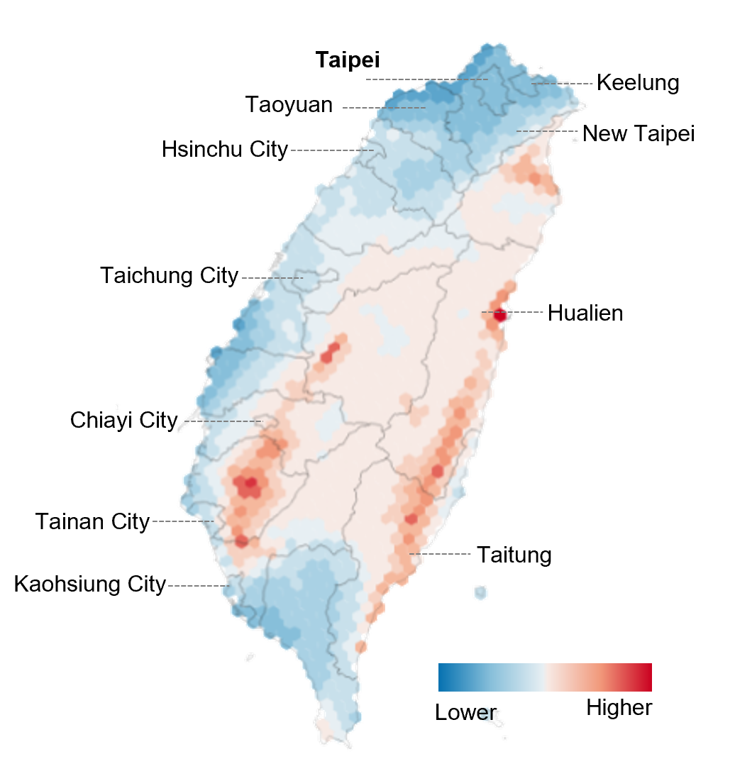
These 3 events were caused by fault sources on the western side of the island, and some of these faults can combine into multi-segment ruptures. This hazard can be further amplified by the impact of soil conditions, particularly in the Taipei Basin and the Chianan Plain. Figure 3 shows the seismic hazard, with soil amplification taken into account, from the Global Earthquake Model (GEM, based on the Taiwan Earthquake Model, TEM 2020).
Figure 3: 475-year return period seismic hazard map with soil amplification from Global Earthquake Model (based on TEM 2020).
Source: GEM
In Taiwan, mountain ranges rising to almost 4,000 meters run parallel to the island’s eastern coastline, constraining human activities to the western plains and basins. About 75% of Taiwan’s population of 23.5 million is concentrated in seven 1-million-plus cities: Taipei, New Taipei, Taoyuan, Taichung, Changhua, Tainan and Kaohsiung. Many economic, cultural and governmental activities are associated with these population centers.
In addition, Taiwan possesses a large high-tech industry that delivers electronic parts worldwide. In particular, the 3 major science parks in Hsinchu, Taichung and Tainan create very large industrial exposure concentrations. Along the coast, the island has several ports. The largest, Kaohsiung in the southwest, handles about 5,000 vessels and 10 million TEUs [3] annually. Although Taiwan’s eastern region has higher seismicity, the area is mountainous and less populated, with 3 counties accounting for 4% of the island’s total population. Nevertheless, the eastern coast’s scenic locations are important sources of Taiwan’s tourism revenue.
To protect lives and economic activities, Taiwan’s government has approached the challenge of earthquake resilience from many angles. Below, we will discuss these efforts to improve the island’s property resilience and financial stability, taking lessons from historic earthquakes, both locally and around the world.
Property Resilience
Evolution of Seismic Design
The first seismic design regulations in Taiwan were introduced in 1974 as part of the Building Technical Regulations directive and addressed both seismic design and seismic zoning. Design requirements, based on the format of the US Uniform Building Code, were applied solely on the location of a building, with Taiwan divided into 3 zones (strong, moderate and light) depending on the frequency, magnitude and intensity of earthquakes in the various regions of the island.
In 1982, the code was updated to take into account the importance of the buildings, with stricter design requirements for buildings considered critical to support disaster recovery or that contained potentially hazardous material. Table 2 shows how buildings were categorized by importance levels and their usage coefficients for amplifying the design requirements.
Table 2: Buildings by importance level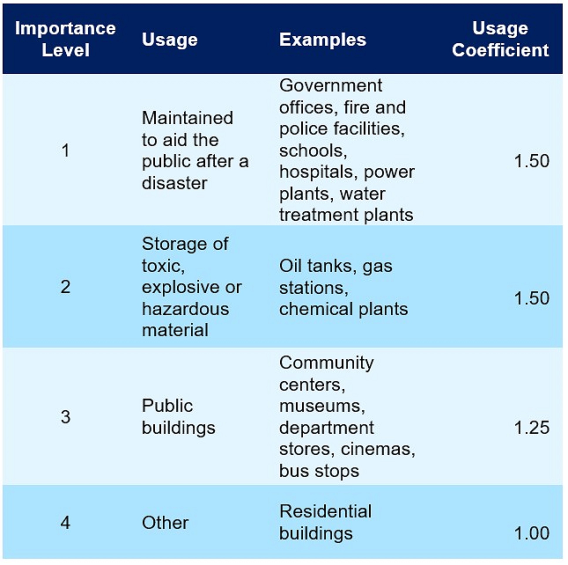
Source: National Center for Research on Earthquake Engineering
As a consequence of the severe damage observed from the 1985 Mw 7.5 Mexico City and 1986 Mw 7.4 offshore Hualien earthquakes, updates in 1989 and 1997 took into consideration basin effects, including the special designation of the Taipei Basin based on its unique geological conditions. Meanwhile, methods for assessing soil liquefaction were included in response to the severe ground deformation observed during the 1995 Kobe Earthquake in Japan. The 1997 update also saw more stringent regulations for the detailing of reinforced concrete structures.
The Chi-Chi Earthquake itself had 2 major impacts on Taiwan’s seismic building requirements. In 1999, the Central Geological Survey of the Ministry of Economic Affairs reclassified the Chelungpu Fault as a highly active fault, immediately increasing the design requirements for buildings in nearby zones. In 2005, the near-fault effects observed during the Chi-Chi Earthquake also led to increased design requirements for buildings in close proximity to faults. The 2005 update also rationalized the seismic zone divisions and there were minor updates in 2011, with an adjustment in the sub-zoning to the Taipei Basin and new regulations for base isolated structures.
The most recent update of seismic design regulations, issued in 2022, includes 4 major revisions: 1) increasing seismic safety near fault zones, 2) improving earthquake resistance of buildings with weak ground floors, 3) refining soil liquefaction data and anti-liquefaction design and 4) ensuring the design quality and effectiveness of seismic isolation and damping elements.
Apart from the revisions, Taiwan’s seismic design regulations also follow relevant standards of the ACI (American Concrete Institute), which are updated every 3 to 5 years.
Special Seismic Design for Taipei 101
About 5 years after the Chi-Chi Earthquake, the Taipei 101 skyscraper opened as the then-tallest building in the world. Its construction, in close proximity to the Shanchiao Fault, highlighted the complexity of designing a tall structure exposed to high levels of hazard from both earthquakes and typhoons, since the structural attributes required to increase seismic resistance can conflict with those required to promote wind resistance.
The engineers overcame this challenge by designing initially for stiffness and wind resistance and then installing additional features to ensure seismic stability. These included a dual structural system, in which steel moment frames worked in parallel with the main system of core plus outriggers, and the installation of a 660-ton steel tuned mass damper near the top of the structure to limit the sway induced by high wind loads and earthquakes. In 2002, during construction of the tower, Taipei was struck by a Mw 6.8 earthquake. Although a crane collapse resulted in 5 fatalities, the structure itself suffered no damage, giving an indication of its seismic stability.
Upgrades for High-Tech Manufacturing Plants
Almost immediately after the Chi-Chi Earthquake, the Taiwan Semiconductor Manufacturing Company (TSMC) introduced its own new seismic design standards, which went beyond the legal requirements for both structural and non-structural components. In subsequent years, state-of-the-art anti-seismic technology has been employed, such as the installation of dampers in new facilities to reduce the seismic response and the adoption of base isolators and energy dissipation devices to minimize structural damage. Notably, seismic isolation plates were adopted for furnace tools, incorporating energy dissipation technology to reduce earthquake intensity by 50% for vertical furnaces.
Additional measures have included the installation of floating piles at new facilities in Tainan Science Park and improved anchorage of equipment. The first Earthquake Early Warning System was also established in 2015. These efforts by TSMC and other manufacturers laid a solid foundation for the industry’s resilience in subsequent earthquakes. Basically, structural damages have been largely avoided. Comprehensive reviews took place after each earthquake, and further measures were implemented to protect contents and ensure business continuity.
Retrofitting Existing Buildings
Retrofitting efforts have been divided into 3 large property groups: private homes, public buildings, and schools. Each has its own challenges and requires different approaches.
Private Buildings
Retrofitting private buildings has been challenging because of multiple ownerships and the financial burden to be shared among all owners. Residents often need temporary housing during the retrofitting process, making it difficult to reach a consensus for comprehensive retrofitting or rebuilding. To address these challenges, the government approved the Taiwan Building Seismic Safety Inspection and Assistance for Reconstruction and Retrofitting Plan in 2018.
This plan commissioned the Taiwan Center for Research on Earthquake Engineering to assist building owners in implementing interim seismic reinforcement measures while waiting for all owners’ agreement on comprehensive retrofitting or reconstruction. The primary goal of this plan is to significantly reduce the risk of damage to the weak layers of buildings. To encourage the public to undertake seismic reinforcement, the Ministry of the Interior Construction and Planning Agency provides subsidies based on the size of the reinforcement area, with a maximum subsidy of TWD 4.5 million per case.
Public Buildings
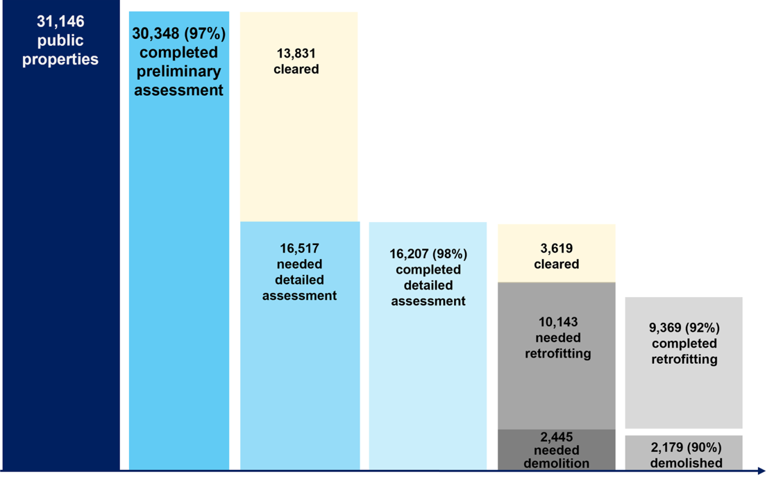
In 2000, the government launched the Seismic Capacity Assessment and Retrofitting Program for Public Buildings, which targets public buildings, such as government offices, hospitals and other essential services, to ensure their functionality during and after an earthquake. In 2017, the program was expanded to include public retail market buildings. There are 3 stages of this program: preliminary assessment, detailed assessment and retrofitting or demolition (if considered not suitable for retrofitting).
As of the end of 2022, 30,348 out of a total of 31,146 buildings had completed the preliminary assessment and moved on to the next stages. In total, 30% of the original public properties have completed retrofitting. Figure 4 illustrates the assessment and action stages.
Figure 4: Assessment stages of public properties.
Source: National Land Management Agency
Schools
From 2009 to 2022, the government funded TWD 128.4 billion for seismic assessments and retrofitting of schools. In these 14 years, the seismic capacities of 9,550 school buildings were upgraded.
The effectiveness of school building retrofitting was quickly demonstrated during the 2010 Mw 6.3 Kaohsiung Earthquake. It was observed that 25 out of 469 school buildings awaiting retrofitting in Taichung, Changhua and Nantou experienced light structural damage, whereas only 2 out of 439 retrofitted-school buildings in the same area experienced light structural damage, with the latter ratio being less than one-tenth of the former.
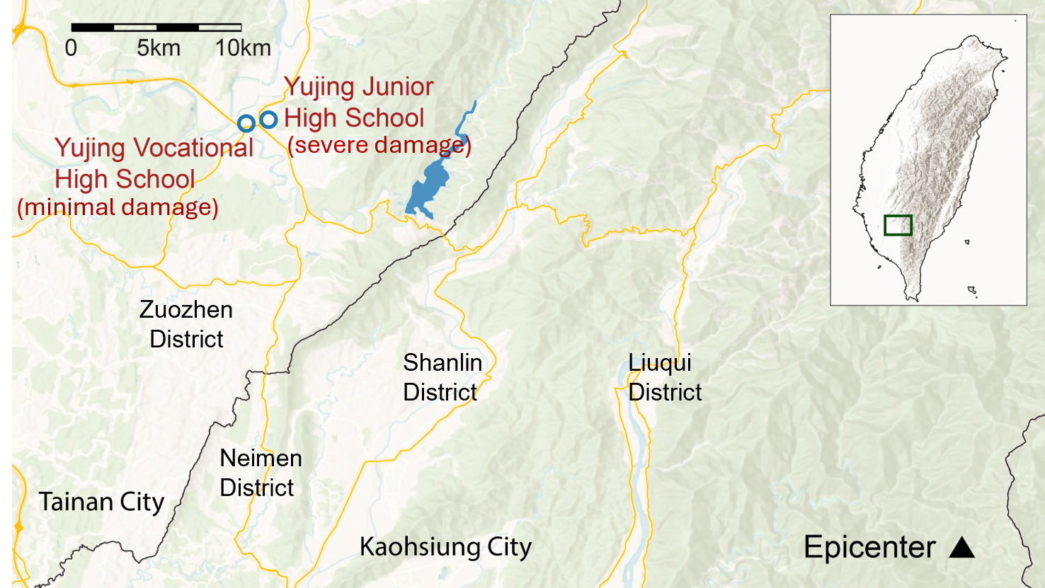
An even more striking example was given by 2 proximate schools, the Yujing Junior High and Yujing Vocational School. They are 1.2 km apart, and both are approximately 30 km from the earthquake's epicenter (see Figure 5), causing them to experience similar levels of intense shaking. Notably, the Yujing Vocational High School, which had completed retrofitting with wing walls and shear walls in 2009, experienced only minimal damage, whereas Yujing Junior High School, which was still awaiting seismic retrofitting, suffered severe structural damage.
Figure 5: 2 schools during the 2010 Kaohsiung Earthquake.
Financial Resilience
Residential Earthquake Insurance
In 1996, California established the California Earthquake Authority (CEA) following the 1994 Northridge Earthquake. In 2000, Turkey formed the Turkish Catastrophe Insurance Pool (TCIP) following the Izmit Earthquake. These precedents had prompted Taiwan to consider an earthquake pool to create a public-private partnership to provide affordable earthquake coverage. The Chi-Chi Earthquake accelerated the urgency.
The Taiwan Residential Earthquake Insurance Fund (TREIF) commenced operations on April 1, 2002, with the primary goal of creating a well-structured and reliable insurance mechanism to provide financial relief to individual residents. The fund covers fires, explosions, landslides, land subsidence, land movement, land fissure, land rupture, tsunamis and sea surge or flood caused by earthquake or other seismic activity.
The TREIF coverage is bundled and sold with residential fire policies through private insurers. For operational efficiencies, TREIF pays only if a home experiences a total loss. The fund pays the lesser of TWD 1.5 million or the building’s replacement value, and TWD 200,000 for contingent living expenses for an annual premium of TWD 1,350. The occurrence of total loss can be determined by a government agency or a professional association for architecture, building structure, civil engineering or alike that the residence is uninhabitable, and the repair costs equal to or exceed 50% of the home’s replacement value. Since the banks require fire and earthquake bundled policy when issuing a mortgage, most of TREIF’s exposures come from homes with mortgages.
Prior to the Chi-Chi Earthquake, about 1% of Taiwan’s households had earthquake coverage. Since the inception of TREIF, the take-up rate has increased steadily, reaching 37.85%, covering 3.5 million household units as of year-end, 2023. Local insurers offer additional earthquake insurance to cover the gaps of partial building and content losses, and losses above TWD 1.5 million.
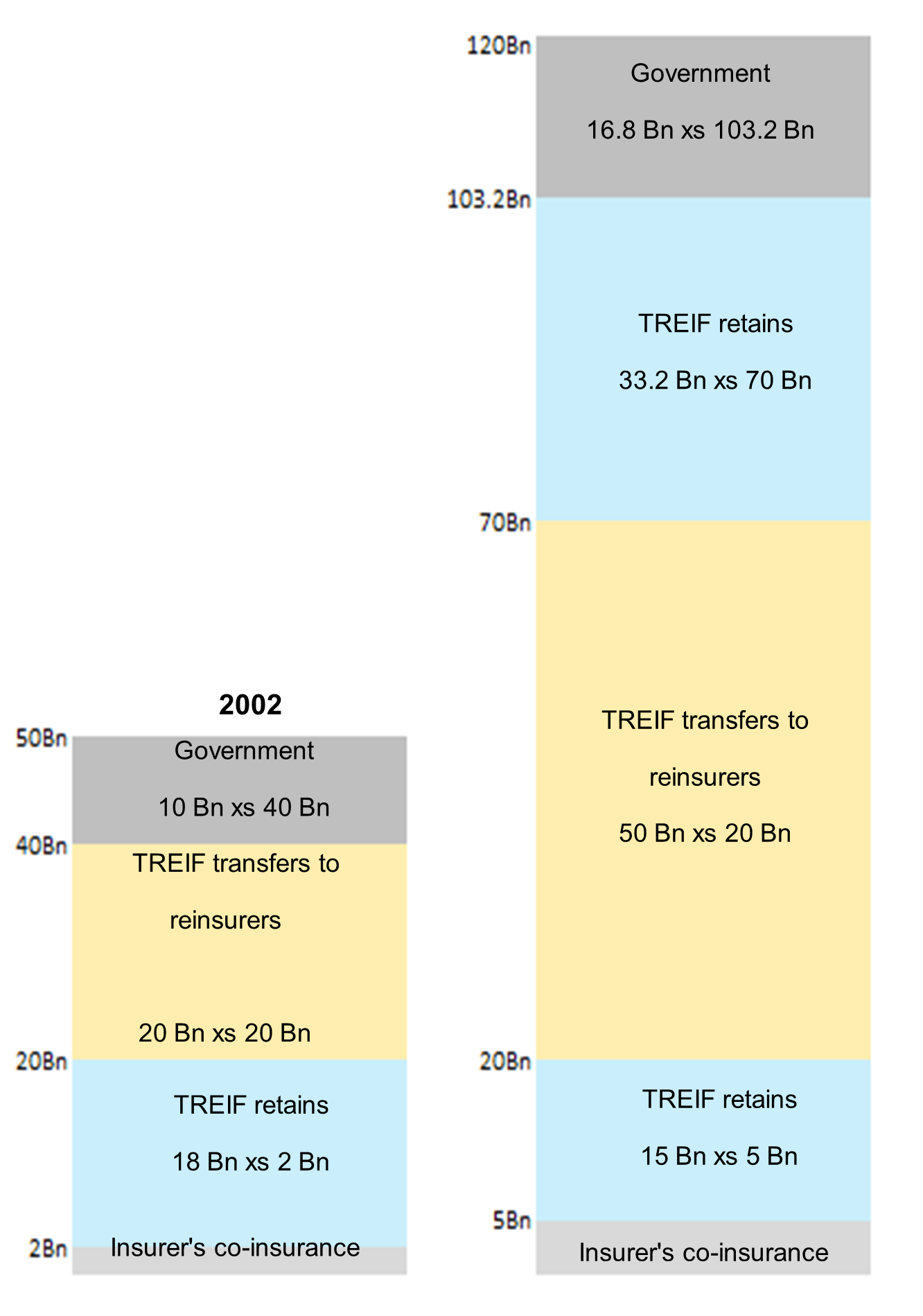
With the increase in take-up rate, TREIF’s cumulative exposures have become larger. Since 2002, TREIF has increased its event funding from TWD 50 billion to TWD 120 billion, as of April 2024, to meet greater financial demand. An event loss is constrained to cumulative claims within 168 hours, and if an event loss exceeds TWD 120 billion, then reimbursements to insureds will be paid on a pro-rata basis.
Financing is shared by multiple capital providers, including worldwide reinsurers. Since its inception, TREIF’s reinsurance layers have not experienced any loss. In 2003, TREIF sourced capital markets and issued a 3-year catastrophe bond (Formosa Re) of USD 100 million. Figure 6 shows the risk-spreading mechanism in 2002 and today.
Figure 6: Structure of risk-spreading mechanism.
Source: TREIF
Reinsurance
Taiwan has seen its insurers proactively enhance their reinsurance protection schemes, especially following the Chi-Chi Earthquake. Before this event, insurers managed their earthquake exposures primarily through proportional treaties and facultative arrangements, with a modest amount of excess of loss (XoL) protection. However, the 1999 event marked a pivotal shift in the reinsurance landscape.
Following the earthquake, reinsurers generally changed their risk appetite and preferred to exclude natural perils from proportional treaties. In turn, insurers have increased the limits of their catastrophe XoL protection to ensure they have adequate coverage for potentially large-scale losses. Many insurers have also moved toward pure XoL schemes for their catastrophe exposure management, providing a focused and effective protection for their net retained books against catastrophic events. This shift has allowed them to better manage their exposures and ensure continuity in the face of natural disasters. In addition to catastrophe XoL programs, insurers also purchase risk XoL to provide coverage for large individual risks. Many of these risk XoL recoveries inure to the benefit of the catastrophe XoL.
In addition, insurers have increasingly used sophisticated catastrophe models to obtain a better view of their earthquake exposures. These models are helpful for considering loss potentials arising from physically possible but historically unprecedented events. Cognizant of the limitations of models’ capabilities based on a few worldwide events, some insurers have tailored the default models to their specific portfolios and crafted their own views of risk. By adding catastrophe models to their exposure management, insurers benefit from a broader understanding of both the earthquake peril and the many factors that contribute to earthquake claims. These models constitute an important part of the insurers’ toolkit to determine the appropriate retentions and limits for their catastrophe XoL programs and overall capital management to provide greater financial stability.
Summary
Taiwan is located in a seismically active area, with most events arising offshore or along the less populated eastern region. Since 1900, 3 significant onshore earthquakes have occurred in the western region, the most recent of which was the Chi-Chi Earthquake of 1999. This event, preceded by a lull of more than 50 years in major activity, was seminal in encouraging the development of more resilient buildings and economic stability. The resulting improvements in seismic design and retrofitting dramatically decreased building damage in recent events.
The relatively moderate damage from this year’s Hualien Earthquake clearly illustrated the value of Taiwan’s earthquake preparedness. The creation of TREIF and risk transfers to the global reinsurance market have brought improved financial security to homeowners and insurers. Nevertheless, continued efforts are needed to provide greater resilience against earthquakes by narrowing the protection gap for households and businesses.
Taiwan remembers the Chi-Chi Earthquake every year on September 21, with activities linked to disaster prevention. By drawing lessons from not only Chi-Chi and other local events, but also major earthquakes around the world, the island has accelerated progress in developing resilience against future events.
Chi-Chi Earthquake: Resilience After 25 Years
Register for event updates from the Guy Carpenter CAT Resource Center
[1] Magnitude cited from USGS, however also classed as Mw 7.6 by some other scientific sources.
[2] 1 USD = 32.0370 TWD, Bloomberg (2024/09/02)
[3] TEU refers to 20-ft-equivalent-unit-long containers. The most common dimension is 20 ft x 8 ft x 8.5 ft, with an internal capacity of 1,172 cubic feet (33.2 m3).
Sources: Department of Household Registration, Directorate-General of Budget, Accounting and Statistics, National Center for Research on Earthquake Engineering, TREIF, National Fire Agency, International Seismological Centre, Global Earthquake Model, Wikipedia, TSMC, National Land Management Agency