

Summary
- Current Status: Helene has attained hurricane status. As of 11 a.m. EDT on September 25, 2024, the center of circulation is located about 85 miles NNE of Cozumel Mexico with maximum sustained winds of 80 mph. Tropical storm winds, hurricane force gusts, and heavy rain are currently impacting Western Cuba and the Yucatan Peninsula. Conditions will improve in these areas as Helene continues to lift north through the Yucatan Channel on Wednesday.
- Forecast Track: The National Hurricane Center (NHC) is still expecting Hurricane Helene to make landfall in the Florida Big Bend region late Thursday as a major hurricane. The storm is beginning to interact with a frontal system located over the Central Mississippi Valley, which will pull the storm northward towards the Gulf Coast. Helene’s forward motion will begin to accelerate as it moves north, helping to shorten the duration of impacts, but also bringing hurricane and tropical storm force winds to inland regions of Georgia and Alabama.
- Rapid Intensification to Begin: Helene has entered an environment of low wind shear and ample atmospheric moisture, allowing for steady intensification over the past 24 hours. The storm is in the process of building its eyewall. Once the eyewall is complete, Helene should begin a period of rapid intensification into a major hurricane. Exceptionally warm water at depth, a lack of vertical wind shear, and ventilation from the frontal system over the Mainland will support this process. The NHC expects Helene to peak as a category 3 hurricane with maximum sustained winds of 125 mph prior to reaching the Northern Gulf Coast (and landfall as a category 4 hurricane cannot be ruled out).
- Historical Analogs: In the past 50 years, 4 hurricanes of category 2 or greater strength have made landfall within 100 miles of Tallahassee, Florida. Hurricane Idalia (2023) may be the best physical analog in terms of intensity and landfall location. Elements of population concentration and the exceptional size of Helene along with its expected strength will be important factors to influence industry losses.
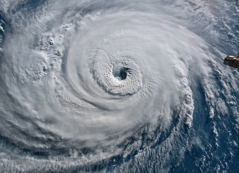
- Large Storm: Helene is a very large storm, and it will maintain its size at it traverses the Gulf of Mexico. The NHC noted yesterday evening that the forecast storm radii are at the 90th percentile of major hurricane size at similar latitudes. Impacts will be most severe along and to the right of the center of circulation, but given the unusually large nature of the storm, surge, wind, and rain impacts will affect most of the Florida west coast regardless of landfall location, and conditions will also extend well inland.
- Expected Impacts: Major hurricane wind conditions are likely to cause substantial damage to property in the Florida Big Bend region, with the most acute impacts near and to the right of the track. Farther away from the center of circulation, most of Florida can expect light to moderate property damage along with downed trees and powerlines due to tropical storm force winds. A storm surge of 10-15 feet is expected over a substantial portion of the Florida Big Bend region. Severe damage to property and infrastructure is expected due to seawater inundation for coastal areas and adjacent waterways, with more severe damage along the immediate coast due to wave battering. Population centers along the Florida West Coast will have to contend storm surge as well due to Helene’ s sprawling size. The NHC is forecasting a storm surge of 5-8 feet in Tampa Bay, raising concerns for coastal inundation in vulnerable areas of the urban core. The acceleration of Helene’s forward speed will limit the duration of impacts for coastal regions but will also introduce enhanced inland wind impacts. The SPC has issued an Enhanced Risk for severe weather for the Atlantic Coast of Georgia along the eastern side of Helene’s circulation. Tornadoes are the primary threat in this region. Helene also poses a significant inland flooding threat in the Southern Appalachians.


Another statement will be issued on Helene tomorrow as it approaches landfall in Florida.
Additional links of interest:
US National Hurricane Center
US National Weather Service
Statements from official forecast and emergency management agencies supersede this update and should be closely followed concerning matters of personal safety.