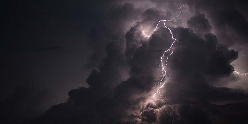
Insights and Study Summary
In recent years, the US has experienced increased losses from severe convective storms (SCS). The trend in losses is the result of combined physical, demographic and economic factors. While there are some noticeable patterns in the physical aspects of these storms, there is still uncertainty regarding their frequency, severity and volatility–especially when considering the impact of human-induced climate change. Academic studies suggest that SCS frequency may surpass the traditional severe weather season in the future, along with changes to areas where severe thunderstorms occur.
As part of our efforts to add to the existing research and develop effective risk management solutions, Guy Carpenter’s (GC) Peril Advisory Team has engaged with Dr. Victor Gensini from Northern Illinois University. Together, we are exploring future projections related to significant hail and tornadoes across the US and southern Canada.
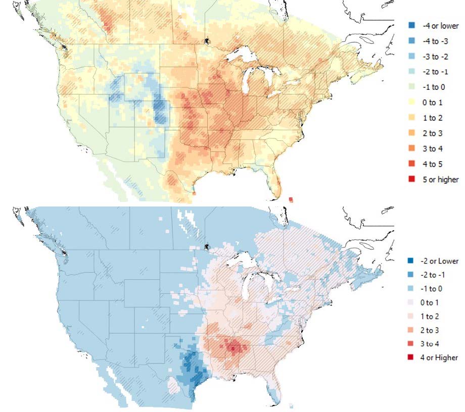
Figure 1: Trend (1979-2020) in large hail environments (top) and significant tornado environments (bottom) expressed in days of increase (warm colors) or decrease (cool colors) per decade. Data generated using the National Center for Environmental Prediction’s North American Regional Reanalysis Model via Northern Illinois University. Hail results consistent with Tang et al. 2019;[1] tornado results consistent with Gensini and Brooks 2018.[2]
Severe Thunderstorm Climate Modeling—An Overview
Severe thunderstorms that produce large hail, tornadoes and damaging winds typically occur in a “favorable environment” where specific conditions overlap. These conditions include:
- Moisture for cloud formation.
- Differences in temperature that create instability.
- Factors that cause air to rise (weather fronts, terrain, daytime warming from the sun).
- Wind shear (changing wind speed and direction with height) that supports storm organization.
Figure 2: The 4 main ingredients required for the development of severe thunderstorms.
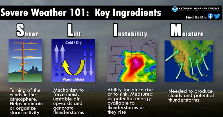
Source: National Weather Service
To study projected changes in SCS activity, researchers often use climate models. These models divide the Earth’s surface into a 3-dimensional grid and solve mathematical equations to simulate atmospheric, oceanic and land surface processes. Global climate models (GCMs) cover the entire planet and provide output at a resolution of 100 to 200 km, spanning several decades to centuries. GCMs have been used to study changes in the environments that stimulate SCS; the results suggest these environments are likely to increase during the 21st century.
However, GCMs have limitations in resolving smaller-scale thunderstorms such as tornadic supercells, which occur on a much smaller scale smaller than 100 km. To overcome this, scientists use regional climate models (RCMs) that take GCM data as input. RCMs have higher resolution—typically 2 to 50 km—allowing for a more explicit assessment of projected thunderstorm activity.
RCMs also have limits, including a smaller spatial domain, a narrower temporal range, and increased computing and data storage requirements. Results from explicit approaches using RCMs suggest a likely increase in the frequency and seasonality of severe thunderstorms by the end of the 21st century.
Figure 3: Conceptual image of a GCM grid across the US with an embedded RCM grid with a higher resolution across the Four Corners region.
Source: Geophysical Fluid Dynamics Laboratory (GFDL) and National Oceanic and Atmospheric Administration (NOAA)
GC Engagement With Northern Illinois University
The GC Peril Advisory Team has collaborated with Dr. Victor Gensini from Northern Illinois University to investigate the frequency and efficiency of SCS environments using novel simulations generated by the university’s Weather, Climate, Society Research Group.[3]
Both GCM and RCM outputs were leveraged to study projected changes in frequency and efficiency of environments capable of producing significant hail (≥ 2 inches) and tornadoes (≥ EF2) at the county (United States) and FSA (Canada) resolution. While many simulations were conducted, the results presented here are based on the National Center for Atmospheric Research Community Earth System Model (CESM) for representative concentration pathway (RCP) 4.5. (a mid-range emissions scenario believed to be the most probable), RCM simulations at 3.75 km were generated via a bias-corrected adjustment of the CESM output.
Significant Hail and Tornado Environments
Researchers use the Significant Hail Parameter (SHIP) to determine if an environment is likely or unlikely to produce large hail (2 inches or larger). The SHIP value considers factors such as instability, moisture, temperature and wind shear—originally developed for operational forecasting purposes.
In analyzing climate model output, it was discovered that the number of days per year with SHIP values greater than one could increase in certain areas of eastern Texas, the Mid-South, and southcentral Canada under the mid-range RCP 4.5 emissions scenario. Conversely, there could be a decrease during these days over western Texas and the central Great Plains.
Figure 4: US regions expected to see an increase or decrease in large hail environment days per year.
Severe Hail Day Changes 2050 RCP 4.5
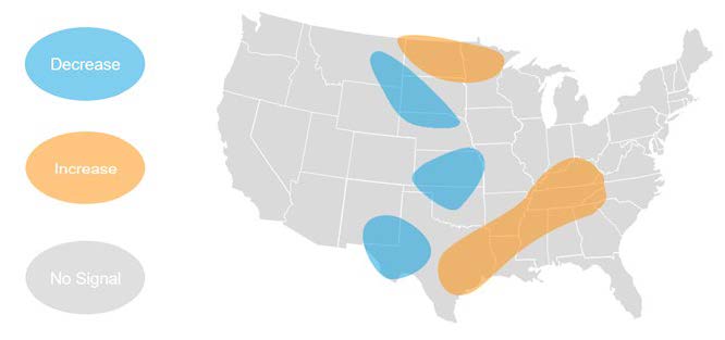
Source: Northern Illinois University/GC
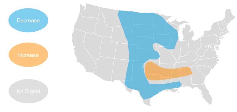
Similarly, researchers use the Significant Tornado Parameter (STP) to evaluate environments capable of producing significant tornadoes (Enhanced Fujita Scale [EF2] or stronger). Our study found that there could be slight decreases in the number of annual days over the central Great Plains and parts of the upper Mississippi Valley, while increases are suggested in the Mid-South, Northern Plains, Southeast, and parts of the Northeast.
Figure 5: US regions expected to see an increase or decrease in significant tornado environment days per year.
Strong Tornado Day Changes 2050 RCP 4.5
Source: Northern Illinois University/GC
Overall, these findings align with previous research suggesting an increase in environments favorable for SCS in some parts of North America and a decrease over the Great Plains. It is important to note that year-to-year variability remains a concern, and areas with projected decreases in activity can still experience volatile weather patterns with large hail and significant tornadoes.
These potential changes may be concerning, especially for areas in the southern US that are more vulnerable to tornadoes, as well as New England, which typically has low significant tornado frequency. For more context, researchers also evaluate the efficiency of hail and tornado environments in the regional climate model simulations.
Significant Hail and Tornado Environment Efficiency
In SCS research, RCMs are used to study thunderstorms and related processes on a smaller spatial scale. Despite the smaller scale, RCMs are still unable to directly simulate tornadoes, which occur on an even smaller scale, typically less than 1km. Instead, simulated meteorological variables, including radar composite reflectivity and updraft speed and spin, are used to track proxy tornado events in the RCM output. For hail, the maximum hail size is estimated from simulated cloud characteristics, including temperature and moisture (specifically the Thompson microphysics scheme).
To assess RCM efficiency, the number of days with SHIP and STP environments greater than one in the GCM is compared to the number of days with proxy events in the RCM at county and FSA resolution. An efficiency value of one indicates that the GCM and RCM produced the same number of environment and proxy days, while a value less than 1 suggests that the GCM overestimated the number of environment days compared to the RCM proxy days.
The analysis of efficiency metrics and RCM proxy days showed mixed results. There was no clear indication that environments for significant hail and tornadoes would become more productive in the analyzed areas. However, there were some indications of discrepancies between the number of GCM environment days and RCM proxy days, suggesting that certain thunderstorm ingredients or localized features resolved by the model may influence this relationship. Further research is needed to investigate these factors.
The suggested changes in RCM proxy events for hail and tornadoes were similar under different emission scenarios, indicating that the distribution of storms producing significant hail and tornadoes remains consistent. This suggests that the simulation variables used to track these hail and tornado proxy events capture similar thunderstorms, resulting in similar spatial patterns.
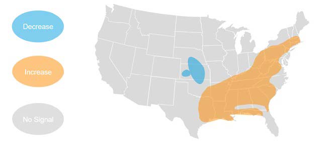
The analysis also showed decreases in annual days for proxy hail and tornado events combined over much of the Midwest and Great Plains under both emission scenarios. However, an area of increase was suggested over the Arkansas-Louisiana-Texas region, extending slightly into the Mid-South. These findings align with previous research on potential changes in supercell thunderstorm activity. More work is needed to evaluate the significance of the projected changes and to examine further the specific thunderstorm ingredients driving these changes in proxy event frequency.
Figure 6: US regions anticipated to see an increase or decrease in hail and tornado proxy events combined.
Total Severe Weather Days (Tornado and Hail) 2050 RCP 4.5
Source: Northern Illinois University/GC
Conclusion
The research engagement with Dr. Victor Gensini and GC offers valuable insights into how hailstorms and tornadoes might change in the future. While there are some indications of possible increases or decreases in certain areas, the results also show that SCSs are complex and uncertain. Ultimately, more research is needed to explore these questions further.
It is important for industry and academic partnerships to continue severe weather research to improve our understanding and develop better risk management strategies. Although additional investigation is needed to evaluate different climate models and scenarios, the results from our research are beneficial to better understand geographies that are potentially more or less susceptible to severe weather by mid-century.