
Following the first Helene post event report, this second discussion delves more deeply into several aspects of the event. As is the case with most major catastrophes, a cascading set of variables came together simultaneously to result in the wide range of impacts. The devastating inland flood event is examined through a lens of infrastructure risk, particularly examining the state of dams and levees in the United States. Climate change is increasingly playing a role in events such as Helene. Finally, this report investigates a range of impacts to the insurance industry and broader economy.
Hurricane Helene Post-Event Report Part 2
Dam Safety and Infrastructure Under Duress
History of Dam Failures in the US
Dams and reservoirs are critical components of America’s infrastructure, safeguarding communities from devastating floods. According to the National Inventory of Dams (NID), there are over 92,392 dams in the US, regulating more than 75% of major rivers. However, aging infrastructure, poor structural ratings, and designs that do not account for climate change increase the risk of catastrophic dam failures. Between January 1900 and September 2020, the Association of State Dam Safety Officials recorded 393 dam breaks and 693 incidents that could have led to failures without intervention. Notable recent incidents include the Oroville Dam crisis (2017) and the Edenville and Sanford dam failures (2020).
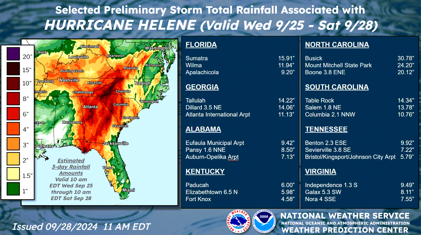
On September 27, residents downstream of 2 North Carolina dams were evacuated due to potential "catastrophic failure" amid flooding from Hurricane Helene. The Walters Dam, operated by Duke Energy in Haywood County, and the Lake Lure Dam, located about 25 miles from Asheville in Rutherford County, faced critical conditions as excessive rainfall caused water to crest behind the dams and flow around their walls. While structural supports were compromised, the dam itself remained intact without failure.
The Waterville Dam and Lake Lure Dam, built in 1929 and 1927 respectively, are nearly a century old and classified as “high” hazard dams. The Lake Lure Dam was last assessed in 2023, rated as "fair", the second lowest of four classifications. On September 28, the Tennessee Valley Authority issued a Condition Red warning for the Nolichucky Dam, also classified as a “high” hazard dam in Greene County, Tennessee, due to major flooding on the Nolichucky River. Fortunately, subsequent updates confirmed the Nolichucky Dam was stable as floodwaters began to recede.

Resiliency Approaches to Flood
To address the low flood insurance uptake in areas affected by Hurricane Helene, an “all of the above” approach is essential for loss mitigation. FEMA’s National Flood Insurance Program suggests that custom-designed levees can protect properties from inundation with minimal structural changes. These levees alleviate pressure from floodwaters that could cause significant damage. In many cases, the cost of constructing levees is less than elevating or relocating structures, allowing residents to remain in their homes during construction.
A successful example of customized flood defense was seen during Hurricane Helene. As coastal water surged in the Tampa Bay area, Tampa General Hospital remained dry thanks to a temporary floodwall. This fortified barrier, constructed in 2019, consists of interlocking modules that can protect entire buildings and withstand surges of up to 15 feet above sea level. Anchored to the ground with straps, the floodwall gains strength as floodwaters rise.

Confluence of Meteorological Factors
Hurricane Helene formed over above-average sea surface temperatures (in excess of 86 °F) in the Gulf of Mexico. The combination of low mid-level wind shear, high levels of relative humidity from the Central American gyre, and interactions with a frontal system over the continental US helped the system to intensify rapidly on September 26. The rapid intensification took Helene from a category 1 storm early in the day to a category 4 storm by the evening, an increase of 35 mph in less than 12 hours. Upper-level winds also helped steer the system north and contributed to how quickly it moved inland.

Confluence of Meteorological Factors
As Helene moved further inland, it interacted with a stalled frontal system, preceding Helene with rainfall throughout western North Carolina and eastern Tennessee. After landfall, Helene slowed down over the southern Appalachian Mountains. Orographic lifting additionally took place as surface-level air was lifted over the mountains, causing additional rainfall as the air cooled in higher elevations. The combination of rainfall ahead of the storm and persistent drought conditions throughout the Southeast US, both contributed to the extreme flooding, as soils simply could not absorb such a large volume of water.

Precipitation totals from Hurricane Helene. Source: NOAA.
Hurricane Helene Timeline


Climate Influences on Hurricane Helene
Hurricane Helene will be a historic storm in many respects, and a question naturally arises on how climate change may have contributed to the devastating effects of the storm. The effects of climate change on the hurricane threat are varied by sub-peril, noting the best view of the Intergovernmental Panel on Climate Change (IPCC) and the US National Climate Assessment (NCA). While climate change on its own does not explain any natural catastrophe, certain effects of Hurricane Helene were likely amplified by climate change.
Sea-Level Rise: Observed sea-level rise is unequivocal. There has been an observed sea-level increase of about 6 inches since 1950 in the Southeast Region, with an accelerated increase in recent years according to the Florida Climate Center at Florida State University. This amplifies the effects of storm surge to produce coastal inundation with greater severity and over a wider footprint. The sea-level increase does explain a portion of the historic storm surge observed along the Florida Big Bend region from Helene.

Excessive Rainfall: It is unequivocal that the number of observed intense rainfall events is increasing on a global basis. Warm air can hold more water vapor to amplify intense rainfall effects and this is a projected trend for hurricanes under global warming. The interaction of Hurricane Helene with another frontal system to its northwest produced excessive rainfall amounts in excess of 30 inches, with historic flood impacts for Northern Georgia and the Appalachians. We have seen events approaching this severity before with events such as Hurricane Camille (1969) and the storm of 1916. Nevertheless, a portion of the excessive rainfall and flood effects of Hurricane Helene are consistent with observed and projected trends under global warming.

Climate Influences on Hurricane Helene
Warming oceans: There is a steady upward observed trend in ocean temperatures on a global basis. Along these lines we have seen exceptionally warm sea-surface temperatures (SSTs) in portions of the Western Atlantic, Caribbean and Gulf of Mexico in 2024 even reaching record levels for certain areas. Warm waters are the essential energy source for hurricane development and intensification.
As water temperatures continue to increase, so will the upper limit to which hurricanes can intensify. Helene crossed an exceptionally warm and deep area of SSTs resulting in explosive growth into the strongest known hurricane to make landfall in the Florida Big Bend region. Helene’s exceptional period of rapid intensification resulted in an increase of 55 mph in less than 24 hours. Despite unclear projections on hurricane frequency, projections are clear on an increase in severe category 4 and 5 hurricanes. The case of Hurricane Helene along with the other rapid intensification cases since 2016 are consistent with this projected view.

Industry and Economic Ramifications of Helene
Economic versus Insured Losses and the Protection Gap
An examination of the top 10 US hurricane loss events ranked by insured loss, relative to the total economic loss since 1980 is highlighted below. Events that have the largest protection gap are either a result of extensive non-insured flood losses (Katrina, Harvey, Sandy, Ike) or major infrastructure damage (Katrina, Maria, Sandy). Hurricane Helene features both extensive flood damage that will be largely uninsured as well as significant infrastructure damage, particularly inland. Federal funding in the form of disaster relief, state funding of infrastructure repair, and corporate funding of power and telecommunications repair will largely be uninsured. Additionally, individual property owners will also be subject to significant repair costs in the event of flood damage.

The projected historic protection gap in Hurricane Helene raises several issues for the insurance industry and the broader US economy and society:
Accelerate pre-event mitigation efforts:
- The Building Resilient Infrastructure and Communities (BRIC) program by FEMA supports state, local, tribes and territories to reduce hazard risk. In helping build capability and capacity, BRIC grants incentivize natural hazard risk reduction activities to public infrastructure and disadvantaged communities. Key focal areas of the initiative include nature-based solutions, enhancing climate resiliency and adaptation, and augment funding for the adoption and enforcements of the latest published building codes.
- FEMA has a range of additional Hazard Mitigation Assistance programs that aim to reduce or eliminate long-term risk to people and property from future disasters. The Flood Mitigation Assistance Program and Flood Mitigation Assistance Swift Current initiative provides funding to reduce or eliminate the risk of repetitive flood damage to buildings insured under the National Flood Insurance Program. The Hazard Mitigation Grant Program provides funding to rebuild in ways that reduce or mitigate future disaster losses in communities.
The insurance industry has a strong role to play in coupling these federal investment dollars with appropriate risk transfer mechanisms to reduce the project gap. Community based catastrophe insurance has the potential to enhance financial resiliency of communities and their residents, provide affordable and reliably available disaster insurance, and create incentives for community-level and individual risk reduction.
Role of Parametric Insurance
While wind insurers will not be responsible for paying flood claims, it is likely many policy holders will file a claim under the wind policy. Insurers will bear expenses to adjust these claims even if insured ultimately does not receive funds under the policy. Parametric structures can play a role in helping to reduce the loss adjustment expense where programs do not otherwise respond.