

Summary
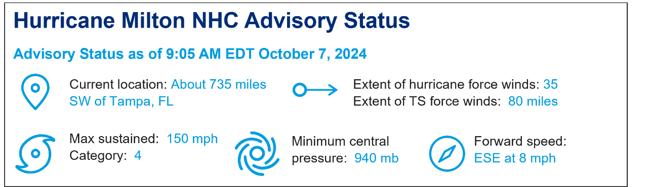
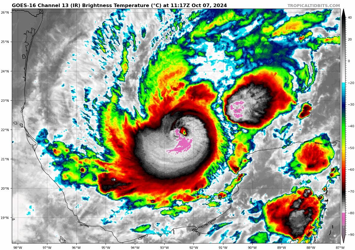
- Current status: At 8 a.m. EDT today, Hurricane Milton is located in the Western Gulf of Mexico, about 150 miles WNW of the Yucatan peninsula. The hurricane has rapidly intensified to category-4 strength, and further intensification is expected today. The National Hurricane Center (NHC) expects Milton to peak as a high-end category-4 or category-5 hurricane within the next 36 hours.
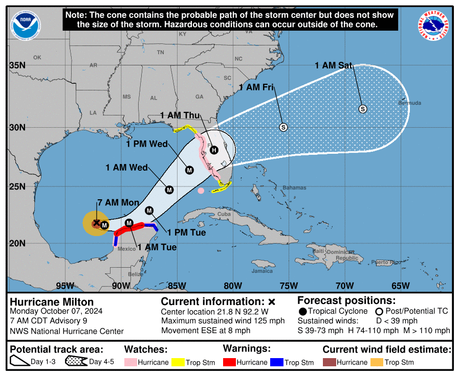
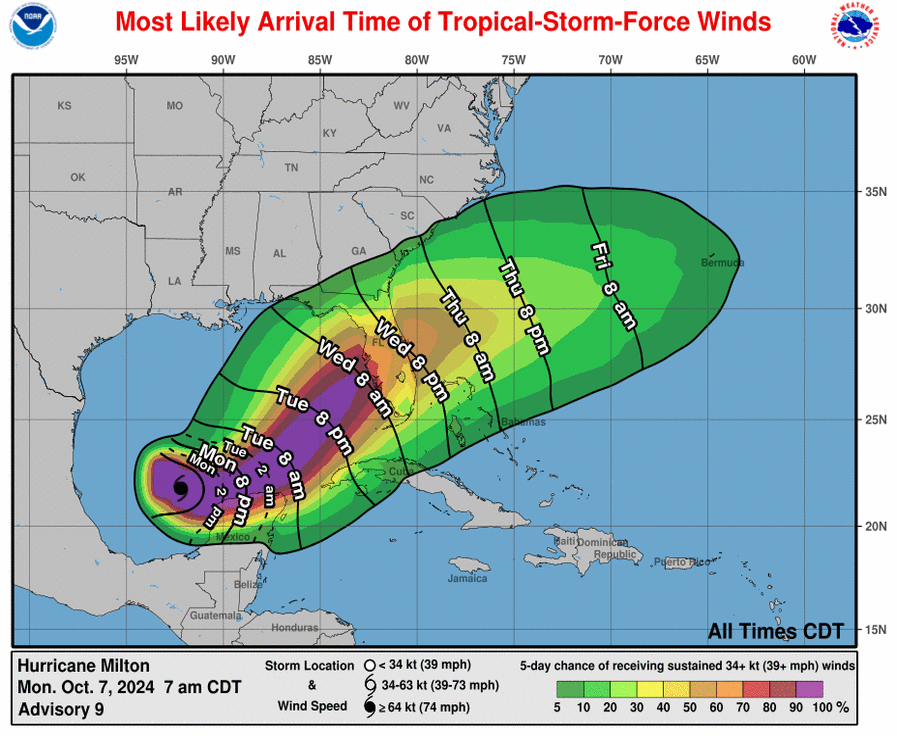
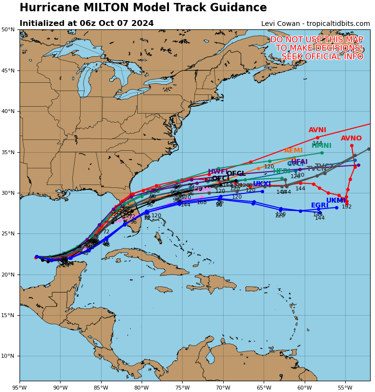
- Forecast track: Hurricane Milton is currently moving east-southeast across the Gulf of Mexico, a unique direction of movement that is the result of a larger weather disturbance in the region. Milton will continue moving ESE over the coming hours, tracking close to the north coast of the Yucatan Peninsula today. Hurricane warnings are currently in effect for much of the Yucatan’s north coast. Milton will begin to move away from the Yucatan on Tuesday, as a second weather disturbance to the north begins to pull the cyclone northeastward towards the Florida Gulf Coast. The precise timing and interaction of these features is still difficult to determine and model guidance shows a range of track scenarios from Fort Myers to south of Cedar Key. Milton should make landfall late Wednesday on the central-west Florida Peninsula coast, with onset of conditions very early Wednesday morning per the NHC.
- Forecast intensity: Over the past 24 hours, Milton has rapidly intensified from a Tropical Storm with maximum sustained winds of 60 mph into a Category-4 major hurricane with maximum sustained winds of 150 mph. This extreme strengthening has been supported by warm waters at depth over the Gulf of Mexico, a moist atmosphere, and reduced wind shear. The NHC expects Milton to further intensify into a high-end Category-4 or Category-5 intensity. As Milton gains latitude, wind shear will be increasing due to this nearby low-pressure system. Increased levels of dry air will also be present, causing Milton to weaken from its peak intensity as it approaches the Florida coastline. While weakening is expected due to this increase in wind shear and dry air, the storm is expected to maintain major hurricane intensity through landfall. While wind impacts may be reduced from peak intensity, storm surge will not be diminished despite Milton’s weakening trend.
- Expending footprint: Milton’s intense winds are currently constrained to a very small inner core, with hurricane force winds extending only 35 miles outward from the center of circulation. Hurricanes with small but intense structures are often subject to eyewall replacement cycles, in which the small inner core gets replaced by a larger and more stable eye. This process will temporarily induce weakening of maximum sustained winds but will lead to an increase in the size of the storm. It is likely that Milton will undergo multiple eyewall replacement cycles over the next few days, leading to intensity variation, but also an enlarged wind footprint. By the time Milton approaches Florida, it will be a much larger hurricane than it is now which will contribute both the overall wind footprint as well as amplified storm surge effects.
Expected Impacts
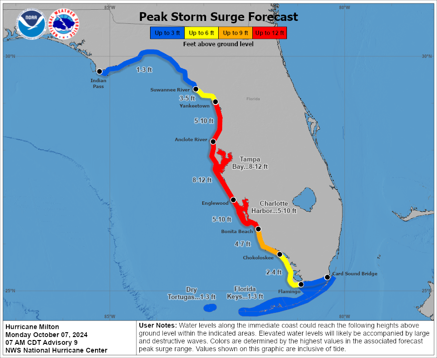
- Storm surge: Historic storm surge is anticipated across a broad region of west Florida, with inundation levels as high as 8 to 12 feet to the south of the landfall location. Specifically for the Tampa Bay and St. Petersburg metro region, the ultimate inundation heights remain extremely sensitive to where Milton comes ashore. A track just north of Pinellas County is a worst case scenario as southeasterly flow into Tampa Bay would amplify inundation directly into the city.
- Major hurricane wind impacts: Wind damage is expected to be significant. The latest forecast shows some weakening late Tuesday into early Wednesday, but Milton is still projected to make landfall as a Category 3 hurricane (and landfall as a Category 4 cannot be ruled out). While the most recent Florida building codes are designed to withstand Category 3 sustained winds, older construction is of concern. An additional element in play is the large amount of debris removal yet to take place from the affected areas of Hurricane Helene. Wind blown debris is likely to be worse than usual, and would be a wildcard for additional damage.
- Societal impacts: Societal impacts are also a concern as Florida is anticipating the largest evacuations since Hurricane Irma (2017) which dislocated 6.7 million residents. Pre-emptive infrastructure closures are also taking place to limit damage to water treatment and sewerage facilities.
Another statement from the CAT Resource Center is scheduled for Tuesday, October, 8, 2024.
Additional links of interest:
US National Hurricane Center
US National Weather Service
National Weather Service Tampa