
Key Headlines
- As predicted, a strong low-pressure system crossing the central US over the weekend brought a major severe thunderstorm outbreak across a broad portion of the central and eastern US while numerous wildfires ignited across Texas and Oklahoma.
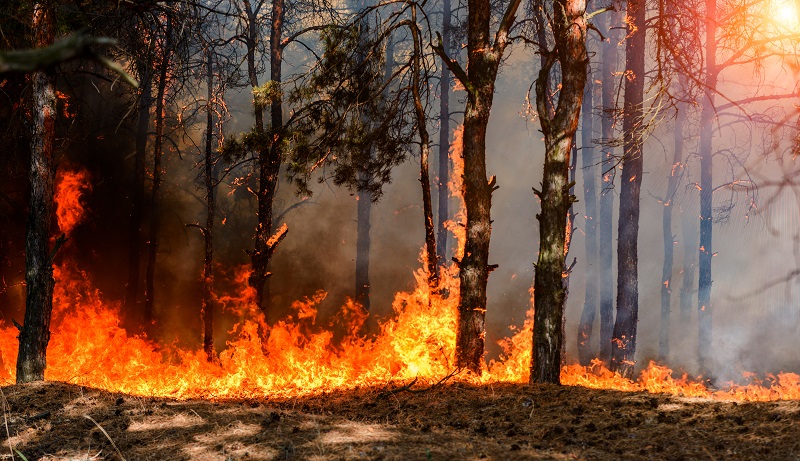
- Wildfire rapidly spread into the town of Stillwater, Oklahoma, and other smaller communities in the state, with over 300 structures damaged or destroyed as of Monday morning, March 17. At least 130 fires across 44 counties broke out under highly adverse weather conditions.
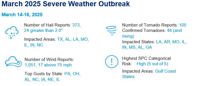
- A multi-day severe thunderstorm outbreak took place as the storm system moved east, with over 1,500 storm reports recorded. Over 40 fatalities have been reported across 10 states, with the highest total of 10 in Missouri. So far, two EF-4 tornadoes have been confirmed in Arkansas; the last time more than one EF-4/F4 were reported in the state was March 1997.
- Elevated winds were also commonplace across other portions of the country. The highest recorded wind gust across the three-day period was in Latrobe, Pennsylvania, with a peak gust of 89 mph as a strong squall line traversed the northeast US.
Mid-March 2025 Severe Weather & Fire Assessment
Wildfire Summary
Over the weekend, a series of wildfires across Oklahoma and Texas have caused the loss of several hundred structures. These fires were driven by unusually high winds, low humidity and dry vegetation due to moderate drought conditions. A broader storm system originating in California moved eastward into drought-stricken areas of Oklahoma, bringing elevated winds, dust storms and wildfires, before spawning severe thunderstorms across the Midwest and South.
- Damage Assessment: More than 300 homes and structures were destroyed statewide, with 74 homes lost in Stillwater, Oklahoma, alone. Other hard-hit areas include Mannford in northeastern Oklahoma and smaller communities such as Wellston, located approximately 30 miles northeast of Oklahoma City. Gov. Kevin Stitt reported losing his own farmhouse near Luther, Oklahoma, located just to the west of Wellston. Damage was reported in 44 counties, with some neighborhoods completely destroyed. Damage assessments are ongoing to identify the exact impact of the wildfires, according to media reports.
- Ideal Weather Conditions for Rapid Fire Propagation: The fires were driven by strong winds (at times reaching hurricane force), low humidity and dry vegetation, creating ideal conditions for rapid fire spread. Winds reached speeds of 55-75 mph, which significantly increased the rate of fire spread and made firefighting efforts challenging. The dormant vegetation combined with minimal recent rainfall created abundant fuels for the fires. Some affected areas had experienced up to 112 consecutive days without rainfall. Although temperature is not the most critical factor in fire severity and spread, warm conditions also contributed to the overall dryness of fuels. The NOAA Storm Prediction Center (SPC) forecast Extremely Critical fire weather conditions, the most severe rating, for Friday, March 14, indicating the expected severity of conditions that day.
- Containment: As of Monday, March 17, the Oklahoma wildfires are not fully contained. While some progress has been made, key fires, such as the Roger Mills and Dewey County fires, are still at 0% containment.
- Ongoing Fire Threat: A Red Flag Warning remains in effect for much of Oklahoma today due to gusty winds, low humidity and dry vegetation. A Fire Weather Watch extends to Tuesday. Conditions conducive to enhanced wildfire activity are expected to persist through Tuesday, March 18, as the SPC forecasts critical fire weather conditions over much of Oklahoma on Monday, March 17 and western Oklahoma on March 18. Extremely critical fire weather conditions are being forecast for the Texas Panhandle and parts of western Texas on Tuesday, March 18.
- Past Oklahoma Fire Activity: Oklahoma is no stranger to wildfires due to its dry climate and strong winds. March is historically the peak month for both fire frequency and acreage burned due to high winds, dormant vegetation, and low precipitation amounts. While most historical fires in Oklahoma have been small, larger wildfires are rare but impactful, including the Anderson Creek Fire in March 2016 that burned over 620 square miles in Oklahoma and Kansas, and destroyed 16 homes, 25 structures, and miles of fencing. The wildfires last weekend will far surpass any historical event in Oklahoma in terms of damage, underscoring the region’s vulnerability during extreme weather patterns.


Severe Weather Outbreak
- Well Forecasted Event: Multiple days in advance, the SPC forecasted the potential for a multi-day severe weather outbreak, which verified along expectations. The rarely issued “High Risk” potential for severe weather, the top rating on the five-category severe weather forecast scale, verified with multiple EF-3 and EF-4 long-track tornadoes.
- Tornado Statistics: National Weather Service (NWS) ground surveys continue across multiple states including tornado reports from 10 separate states from Louisiana to Illinois to South Carolina. At least 48 tornadoes have been confirmed to date including 27 of EF2 strength or higher.
- Wind and Hail: Over 1,000 wind reports were received by the SPC, with the majority along the Interstate 80 corridor from Nebraska to Pennsylvania and New York. Impressively, 7 weather stations in New York State exceeded their highest wind reading on record. Hail occurred mainly with individual supercell thunderstorms on Friday the 14th in Texas, Louisiana, Arkansas, Missouri and Illinois.
- Season to Date: With the prolific amount of thunderstorm wind reports over the weekend, 2025 ranks second behind 2017 for the fastest start to the thunderstorm wind season. Tornado and hail activity is tracking near normal thus far in 2025, with more than 85% of the season still ahead.


