
Key Takeaways
- Cyclone Alfred is the first tropical cyclone since 1974 to hit Brisbane, Queensland, Australia.
- During its slow approach to Southeast Queensland, Alfred brough widespread heavy rainfall and caused major flooding.
- The Australian Reinsurance Pool Corporation (ARPC) expected to provide coverage for a large proportion of claims.
- It seems that Cyclone Alfred is unlikely to cause significant losses for the insurance or reinsurance markets on the scale of Cyclone Wanda.
- By March 12, the Insurance Council of Australia (ICA) reported more than 34,000 claims, with the ARPC’s AUD 10 billion reserve providing a substantial buffer. This capacity significantly exceeds the AUD 409 million in claims arising from Cyclone Jasper in 2023, indicating capacity to handle Cyclone Alfred’s loss.
POST-EVENT REPORT: 2025 AUSTRALIAN REGION TROPICAL CYCLONE Alfred
Meteorological History

Cyclone Alfred is the sixth named tropical cyclone of the 2024/25 Australian region cyclone season, and the second to make landfall. It is the first cyclone to cross the coast near Brisbane since Cyclone Zoe in 1974.
Cyclone Alfred originated from a low-pressure trough over the northern Coral Sea. On February 20, the Australian Bureau of Meteorology (BOM) reported a tropical low off the Far North Queensland coast. The system became a Category 1 cyclone on the Australian tropical cyclone scale, the equivalent of a tropical storm in the North Pacific and Atlantic basins, on February 22 and was named “Alfred.” Cyclone Alfred gradually moved to the east over the next few days, intensified into a Category 2 cyclone on February 24, when it was about 970 km east northeast of Carins.
Cyclone Alfred began a southerly course on February 26. As the cyclone travelled across warm ocean waters of 29 to 30°C, it intensified into a Category 4 cyclone on February 27, the equivalent of a Category 2 hurricane/typhoon on the Saffir-Simpson Hurricane Wind scale. Despite being several hundred kilometers away from the mainland, it started bringing strong gusts and high swells along coastal central Queensland.
On March 1, an upper trough to Cyclone Alfred’s south weakened the system via strong vertical wind shear. The trough also steered the cyclone tracking southeast. BOM downgraded Cyclone Alfred to a Category 1 cyclone on March 2, when it was about 460 km northeast of Brisbane.
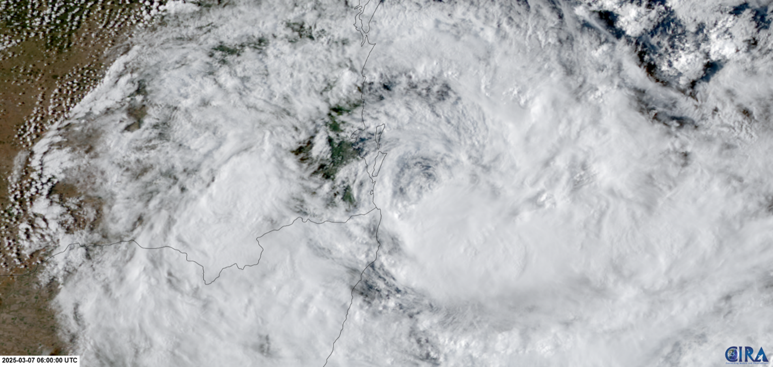
As the upper trough moved away on March 4, a subtropical ridge rebuilt to Cyclone Alfred’s south and steered the cyclone slowly towards the southeast Queensland coast. Marginally warm-enough sea surface temperatures of 26 to 27°C off the southeast Queensland coast maintained Cyclone Alfred as a Category 2 cyclone until it arrived at the coast of Brisbane in the evening of March 7.
Cyclone Alfred crossed Moreton Island, about 40 km northeast of Brisbane, just before midnight of March 8 and quickly weakened. BOM downgraded Cyclone Alfred to a tropical low at 6 am AEST on March 8. The ex-cyclone then stalled off the Brisbane coast most of the day and eventually made landfall at 9 pm near Bribie Island, about 50 km north of Brisbane. It continued moving inland and dissipated by the morning of March 10.

Areas with Extreme Weather and Flooding
Cyclone Alfred posed significant weather hazards to the southeast Queensland coast during its approach. Wind gusts of over 80 km/h were observed along the southeast Queensland coast, with coastal areas in Brisbane and the Gold Coast experiencing wind gusts greater than 100 km/h.
The cyclone also brought widespread heavy rainfall to the region. Between March 4 and 10, Brisbane and the Gold Coast saw a total rainfall of 400 to 600 mm, with some suburbs exceeding 800 mm. March 9 is also Brisbane’s wettest day since January 1974, with a 24-hour total rainfall of 275.2 mm.

Guy Carpenter conducted preliminary mapping of the flood extents using river gauge data from the BOM, satellite data from McKenzie Intelligence Services (MIS), and local council data. Figure 3 illustrates the indicative areas affected by flooding during this event, including both fluvial (riverine) and pluvial sources. Flooding was not widespread and remained largely localised. It is important to note that this mapping is not comprehensive, especially for pluvial flooding outside Brisbane and is based solely on the data available as of March 11, 2025.

Damage Impacts
The wind damage caused by Cyclone Alfred resulted in widespread structural impacts, including fallen tree branches, blocked roads, and uprooted trees throughout the Gold Coast and Tweed regions. The intensity of the winds also led to power outages, affecting nearly 250,000 homes and businesses, marking one of the largest outages in Queensland's history.
Heavy rainfall resulted in major flooding. Lismore, which had previously faced flooding in 2022, saw a recurrence of major inundation as the Wilsons River exceeded its containment thresholds. Evacuations were necessary in low-lying districts in Lismore and Hervey Bay. Flood levels more than doubled in areas such as Grafton to above major flood levels, prompting emergency warnings for several locations around the Tweed River catchments. The Clarence River reached unprecedented heights, threatening critical infrastructure such as bridges and levees.
The heavy rainfall received in Brisbane in under 24 hours, is about 2 months’ worth of average precipitation. It overwhelmed the urban drainage systems and led to extensive localised inundation, particularly in historically flood-prone areas.
As Cyclone Alfred moved westward to make landfall, it coincided with one of the highest tides of the year. As a result, many beaches were stripped of sand, and coastal infrastructure were weakened in some areas. Regions south of the cyclone’s path were particularly hard hit, from the Gold Coast to Coffs Harbour.
Some beaches and dunes experienced significant erosion. For example, Peregian Beach, located south of Noosa, lost up to 30 meters of width. Erosion cliffs reaching heights of up to 3m have formed along the Gold Coast, and most dunes directly behind the beaches were affected by storm surge levels of up to 0.5 meters above the high tide mark, leading to erosion. Even established dunes further inland experienced erosion.
Historical Comparisons
Cyclone Alfred is the first tropical cyclone to make landfall near Brisbane since Cyclone Zoe in March 1974. While Cyclone Zoe impacted mostly northern New South Wales, it amplified existing flood threat as it came only 6 weeks after one of the worst flooding events in Brisbane’s history. Cyclone Wanda played a major part in the floods by supplying tropical moisture to produce heavy rainfall of 500 to 900 mm in 5 days to the area.
There were 2 other tropical cyclones that impacted the area between 1974 and 2025. Cyclone Nancy in 1990 came close to the coast of Brisbane but it did not make landfall. In 2017, Ex-cyclone Debbie’s remnants came to the southeast Queensland coast from the land. The two cyclones generated widespread rainfall and caused flooding as well.

Table 2 shows normalised loss amounts from large historical cyclone events based on the data from the Insurance Council of Australia (ICA). Considering that Cyclone Alfred weakened prior to landfall, occurred in autumn—which limits its ability to gather tropical moisture like Cyclone Wanda—and the implementation of proactive disaster measures in Brisbane and surrounds, the flooding remained localised. As a result, it seems that Cyclone Alfred is unlikely to cause significant losses for the insurance or reinsurance markets on the scale of Cyclone Wanda.

Managing Losses from Tropical Cyclones
The Australian Reinsurance Pool Corporation (ARPC) established its Cyclone Reinsurance Pool on July 1, 2022, with the objective of alleviating insurance premium pressures in cyclone-vulnerable areas by reallocating risk from private insurers to a government-supported mechanism.
Acting on guidance from the BOM, the ARPC declared the start of Cyclone Alfred at 8:30 p.m. AEST on February 25, 2025, and end at 6:00 a.m. AEST on March 8, 2025. The claims eligibility period extended to 6:00 a.m. on March 10, 2025, encompassing a 48-hour window following the event’s official end.
In the case of Cyclone Alfred, the ARPC is believed to have offset a considerable share of reinsurance expenses, thereby lessening the financial burden on insurers. By March 12, the ICA reported over 34,000 claims, with the ARPC’s AUD 10 billion reserve providing a substantial buffer. This capacity significantly exceeds the AUD 409 million in claims arising from Cyclone Jasper in 2023, indicating capacity to handle Cyclone Alfred’s loss.
Historical cyclones such as Cyclone Debbie (2017) and Ex-Tropical Cyclone Oswald (2013) with normalised insured losses of AUD 2.3 billion, and AUD 1.6 billion respectively, highlight the dominance of flooding over wind-related impacts, particularly as cyclones transition into tropical lows. While ARPC’s cyclone pool has reduced premium volatility, its 48-hour coverage restriction fails to address losses from extended flooding, a recurring challenge in such weather systems.
Insurers are increasingly concerned about the rainfall aspect of tropical cyclones, which has become a significant contributor to damages. This issue was evident in the Jasper event of 2023, where insurers faced high losses due to extended flooding beyond the coverage period. The current policy design has faced criticism for not aligning with the changing dynamics of cyclones and their impacts.
Sources
Australian Bureau of Meteorology, Australian Broadcasting Corporation, National Emergency Management Agency, New South Wales State Emergency Services, Queensland Government Disaster Management, Weather Zone, Brisbane Times, The Conversation, SBS News, Insurance Council of Australia, Cooperative Institute for Research in the Atmosphere