
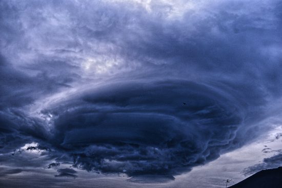
Despite an extremely below average May in terms of severe weather activity, recent events, particularly a number of which were wind-driven, have seen an uptick during the first third of June. Three separate derechos were observed in just the first 10 days of June, in addition to other
widespread convective activity:
- A widespread wind and hail event brought damaging hail upwards of 2 inches and wind gusts over 60 mph to much of the Great Lakes region on June 2.
- The following day, June 3, the same weather system produced a derecho on that spanned much of the states of Pennsylvania and New Jersey.
- An unusual derecho forming in eastern Utah and western Colorado on June 6 brought wind gusts over 100 mph to parts of the Northern Plains.
- Earlier this week, Tropical Storm Cristobal took a rare trek due north following landfall along the Louisiana coastline. This unique track inland brought significant rainfall and associated severe weather activity to much of the northern Midwest. As Cristobal’s remnants crossed the US-Canada border, they merged with a strong upper level disturbance, resulting in the production of severe thunderstorms and yet another derecho impacting much of the Great Lakes Region.
As detailed in a previous post, derechos are unique weather phenomena characterized by several factors and taking a bow-shaped form on radar. The Pennsylvania-New Jersey derecho on June 3 spanned nearly 500 miles in length and brought its most significant impacts to Southeastern PA, including the Philadelphia metro area, as well as portions of southern New Jersey. Winds topped 80 miles per hour in the Philadelphia metro region and numerous gusts over 90 miles per hour were recorded in Ocean County, NJ.

Lightning imagery via the Geostationary Lightning Mapper (GLM), GOES-16 from June 3 derecho. Source: CIRA/CSU
In contrast to most derechos, the Northern Plains derecho on June 6-7 took a northeastward track, originating in Utah and Colorado sweeping into Wyoming, Nebraska, and western South Dakota. According to the U.S. Storm Prediction Center (SPC), this derecho produced 44 significant wind gusts (over 75 miles per hour or greater). This marks the most significant wind gusts in any single day since at least 2004, and potentially further.
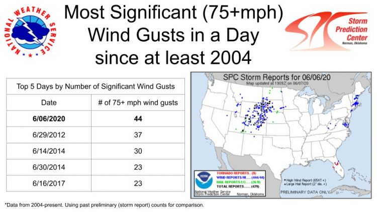
Table of Top 5 Days by Number of Significant Wind Gusts aside a map of local storm reports from June 6. Source: NOAA/SPC
The third derecho in just one week, fueled in part by moisture from Cristobal’s remnants, brought significant impacts to areas of Michigan, Indiana, Kentucky, and Ohio in particular. Severe thunderstorms were also reported by the Meteorological Service of Canada in central and southern Ontario and southern Québec. Reports include large hail and damaging wind gusts for affected areas, including a report of a 120 km/hr wind gust at Chatham-Kent Municipal Airport, and a tornado in the Belmont area. The setup prompted a moderate risk issuance for severe weather, a 4 out of 5 on the risk scale for severe weather, per the SPC. Both the Northern Plains derecho mentioned above and this derecho are classified as “serial” derechos, which typically form ahead of a cold front with the storm energy enhanced by the jet stream aloft.

Local storm reports for June 6, 2020. Source: NOAA/SPC
Together, these derechos in addition to other widespread wind activity through the first third of June in the U.S. have kept damaging straight-line wind reports for the season well above average, despite being only one third through the typical wind season.
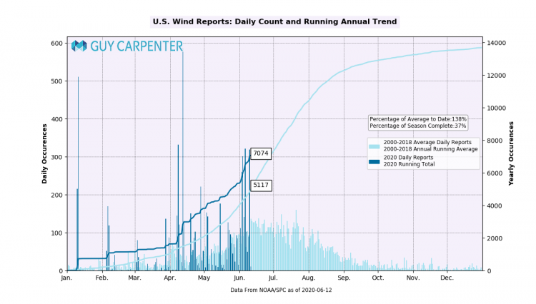
Daily Count and Running Annual Trend of U.S. wind reports to date. 2020 in dark blue, 2000-2018 average in light blue. Source: Guy Carpenter, NOAA/SPC
May 2020: One for the record books
According to SPC reports, May 2020 was significantly below average. While the month of May is typically the most active month of the year in terms of U.S. tornado activity, 2020 defied the status quo. In fact, a number of records were set with last month’s anomalously low level of activity, especially in regards to tornado activity:
- First time that a moderate risk or higher Day 1 outlook had not been issued at any point during the month (1995-present period)
- Fewest number of tornado watches on record (since 1995)
- Fewest number of EF2+ tornadoes in recorded history (since 1950)
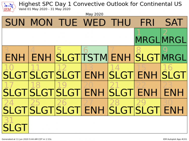
Highest SPC Day 1 Convective Outlook across the U.S. during the month of May, outlining 0 days with a moderate or higher risk. Source: Iowa Mesonet, NOAA/SPC
In addition to the records above, May 2020 observed the fewest severe weather reports (combined hail, tornado, and straight-line wind) since 2014, and the fewest amount of tornadoes since at least 1970.
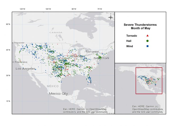
Local storm reports during the month of May 2020. Source: Guy Carpenter, NOAA/SPC
U.S. severe thunderstorm activity typically tends to peak during the month of May, as an abundance of warm, moist air from the Gulf of Mexico over the eastern U.S. meets cold air from Canada and forms a boundary. Upper-level winds tend to peak along this boundary with very strong winds at flight-level, typically called the "jet stream". Winds tend to increase and even change in direction with height along this boundary to produce what is referred to as "wind shear". The most productive environments for severe weather happen when this boundary runs from the Southern Plains towards the Great Lakes. This usually peaks during the month of May.
So why didn't this happen in May 2020? A pattern that developed in May caused a disruption of normal jet stream patterns. Warmer than normal temperatures over Alaska and the Pacific Northwest in addition to a northward deflection of the jet stream produced a southward deflection over the eastern portion of the continent. The result was much colder air than normal sitting over the eastern U.S. This ultimately suppressed thunderstorm development over much of the eastern U.S. resulting in the record-low month of activity.
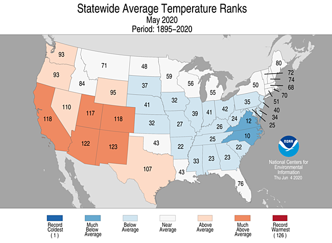
Average temperature ranking by state for May 2020 over the period of 1895-2020. This details the anomalously cold pattern across much of the eastern U.S., limiting severe weather activity. Source: NOAA/NCDC
What is in store for the summer?
With more than half of the tornado and hail season climatologically complete, severe weather during the summer months in the US typically moves to a wind-driven regime. As shown in the image below, both the tornado and hail seasons are more than halfway complete, while the wind season is only one third complete.
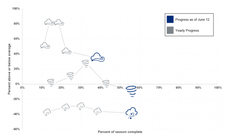
Seasonal activity to date for tornado, hail and thunderstorm wind, relative to 20 year average using SPC preliminary local storm reports. Source: Guy Carpenter, NOAA/SPC
While tornado and hail season tends to escalate in April to a peak in May, straight line winds emerge as the main threat for the deep summer. With the wind season already trending significantly above average, continued activity through the summer months could put 2020 well above the 20-year average.
For more details on Local Storm Reports, please visit the Storm Prediction Center.
This bi-weekly severe thunderstorm recap of the Weather Sentinel will be the last for the 2020 US SCS season. If a significant industry threat of severe weather occurs, or an impactful event is observed, further communication will be issued by Guy Carpenter experts as warranted.
Weather Sentinel notification emails are available on a subscription basis at the GC Preference Center.
Daily, global tropical cyclone alerts are also now available from GC at this link.